A Complete Debunking of the False Claims Supporting the Placing of Mount Sinai In Midian, and an Analysis of the Biblical Text Showing the Biblical Mount Sinai to Likely be in the South Sinai Peninsula, Preferably (Though Not Certainly), at Its Traditional Site at Jebel Ras Safsafeh.
From July 2010
Published online December 30, 2010
Revised continuously until December 29, 2012
Minor revisions on July 25, 2013
From then no revisions until July 28, 2015
From then on no revisions until November 1 through November 4, 2017 (Panoramio shutdown)
In this page I, E. Harding, known on this blog as pithom, have below de-bunked every support for an unsubstantiated hypothesis going around the Internets and the Churches: that a mountain called Jebel al-Lawz (“Mountain of Almonds”), in Saudi Arabia, is Mount Sinai. This hypothesis has been spread mostly by believers of the words of pseudo-archaeologists Ron Wyatt and Robert Cornuke. It has become a popular hypothesis on the web, being spread by hundreds of websites, including arkdiscovery.com, beliefnet.com, bibleprobe.com, baseinstitute.org, the Exodus Conspiracy blog, hope-of-israel.org, Kent Hovind, the Messianic Literary Corner, pinkoski.com, texasgopvote.com, throneofgod.com, wnd.com, wyattmuseum.net, and let’s not forget the vitally important bible.ca! So far, there have been few strong critiques of this hypothesis, those that exist were written by James Hoffmeier, Gordon Franz, Brad C. Sparks, Ed Babinski, Jeffrey J. Harrison and Bryant Wood, the most powerful ones against the Cornuke position being written before Cornuke’s BASE Institute published its partially devastating rebuttals of Franz’s and Sparks’s critiques on its “More Research” page. So far, no one has written a powerful, detailed, post-Franz critique of the Jebel al-Lawz position which has fully taken into account the “More Research” page, Charles Whittaker’s excellent discussions of the physical remains in his “The Biblical Significance of Jabal al-Lawz“, the Biblical, Classical, and Archaeological evidence, and the satellite imagery shown by Google Earth. Until me.
Now, here are the pillars of the idea that Jebel-al Lawz was Mount Sinai and their refutations:
1. Paul of Tarsus said, in Galatians 4:25, that Mt. Sinai was in Arabia and corresponds to (lit. “stands in the same rank as”) the present Jerusalem.
Refutation: The foremost advocate of a Midianite Sinai in the scholarly community, Allen Kerkeslager, believes that “Arabia” was added into this verse as a marginal note sometime before c. 150 AD (Pilgrimage and Holy Space in Late Antique Egypt, pg. 186) for good textual reasons, most notably, redundancy and 3rd century textual evidence. In any case, there is no indication that Paul (certainly any supposed second(?) century scribe)’s geographical regions have to have the same borders as they do in the Old Testament or today. In Paul’s day, Arabia was not just Saudi Arabia, but also, due to the Kedarite migration of the mid-1st millenium BC, which ended up with a 5th century BC Kedarite shrine at Tell el-Maskhuta, 30°33’11″N, 32°5’53″E, included the Sinai Peninsula. This is why, in Greek history’s first mention of Arabia, Herodotus, in the middle of the fifth century BC, who knew nothing of the Gulf of Aqaba and thought the modern day Red Sea (his Arabian Gulf, not his Erythraean Sea) to be the same thickness as the Gulf of Suez, considered the Red Sea to be entirely in Arabia, in his eighth and eleventh paragraphs of his second chapter of his “Histories”, and Arabia to encompass later Trogodytica. Even in the middle of the third century BC, the Jewish Septuagint translators of Alexandria considered all the land east of the Nile to be part of Arabia (LXX, Gen 46:34). Strabo, who lived around 15 AD, also considered all the land between the Nile and the Persian Gulf to be Arabia (Geo. 17.1.21, 30), but did not place the Red Sea entirely in Arabia (17.1.1). The objection that Strabo and Herodotus’s concept of Arabia was wrong because they did not know of the Gulf of Aqaba is fallacious because they put the border of Arabia at the Nile, not at any gulf, and, besides, Strabo did know of both gulfs (16.2.30, 17.1.25-26), even quoting Agatharchides at length, who, contra Rudd, put Poseideium, Palm Grove, and the Garindae country in the Southern Sinai Peninsula (http://tinyurl.com/Agatharabia). It therefore follows that all the land between Oman and the Nile was “Arabia” to Paul. The argument that Josephus, who used political borders, considered the tribes of Simeon and Judah to border upon Egypt and Arabia in Antiquities 5:1:22 is faulty due to the fact that the Egypt of Josephus did not own the whole Sinai peninsula, but only North Sinai, extending from Arsinoe to perhaps Rhinocolura, that is, el-Arish. However, a more likely Egyptian border would be near Quseima, Nitsana, Haluza and Raphia. Besides, Josephus does say Arabia is to the south of Judah in Wars 3:3:5, which the BASE Institute curiously ignores in its list of Josephus’ mentions of Arabia. It also seems rather careless of Cornuke to write “Roman Idumea could only be said to border on Roman “Egypt and Arabia” if the “Sinai” peninsula was considered “Egypt,” and the Arabah (Jordan rift) eastward considered “Arabia.”, for I seem to recall, not just the Nabatean port of Dahab (28°29’39″N, 34°31’1″E), but,“The five Nabatean towns of Haluza, Mamshit, Avdat, Shivta, and Nitzana”. There is no evidence any of these cities paid any tribute to Egypt at any time. The South Sinai was still a part of Petraean Arabia, or could have been, perhaps, at most, a part of Geographical Arabia under the jurisdiction of Egypt, a hypothesis with no archaeological or textual support. While a literal reading of the Paul’s “sustoichos” does support Jebel al Lawz, near al-Bad, classical Madian, as Sinai, there is no clear necessity to read it geographically. In any case, reading it geographically would lead to Mount Sinai being at roughly the same longitude as the Split Rock, not at Maqla (blackened peak) or Lawz (see Section 5).
2. Mt. Sinai was in Midian, since Moses fled to Midian, and fed the flocks of the Midianite priest Jethro. Hey! Even Frank Moore Cross and Eusebius supported it!
Refutation: Firstly, let us all agree Midian was a land located entirely in the Aravah and to the east, in NW Saudi Arabia and southern Jordan (bibleorigins.net/MidianiteAlQurayyaWaresMap.html). There is no evidence (and, indeed, evidence contrary to the assertion) Midian ever extended to the west of the Aravah (eg. 1 Kings 11:18). Now, on to the refutation.
Did Gideon’s War in Judges 6 not take place? What prevented the Midianites from journeying to the Feiran during the unbearable summer months, when Egypt’s mines were unoccupied, and returning to the little-watered land of Midian was foolish, to take a taste of its waters, and, perhaps, to secure or originate its seasonal Midianite ownership? Why not stop at the Mountain of God along the way? Midian is never mentioned anywhere in Israel’s journeys. In fact, the Bible suggests Sinai was not in Midian with the “back to my own land” passages (Ex 18:27, Num 10:29-32). The last passage is grotesquely misused by some Lawz proponents to mean the opposite of what it says. It says “I am going back to my own land”, not “I am staying in my own land”. BASE’s pointing out that “the land of…” is often a geographical, not political designation, is a complete non sequitur for obvious reasons. Indeed, in Exodus 3:1, Moses goes to the back (Strong’s 310) side of the wilderness. The word “back” probably means “west” in this context since the usual term, “seaward” (Strong’s 3220) would simply not apply here. As in Exodus 4:27, 9:27, 13:20, and 23:31, anything south or E. of Palestine and Transjordan not part of any other cultivated region was considered “wilderness”. Since Midian was a wilderness besides al-Bad/Madyan, Ayunah, al-Maqna, and Tayyib al-Ism, Mount Sinai, judging by Exodus 3:1, should be located west of the home of Jethro. Indeed, Exodus 3:1 might imply Mount Sinai is to be sought in the Sinai Peninsula!
Also, any east-of-Aravah (Midianite) location for Mt. Sinai south of 29 degrees latitude, such as Jebel al-Lawz or Hala -’l Badr is strongly discouraged by the Biblical text, for according to Numbers 13:26, Kadesh was in the Desert of Paran, Deut 1:19-20, Num 14:40-45 say Kadesh-Barnea was at the very edge of the hill country of the Amorites, and Numbers 20:16 says Kadesh was on the very edge of Edomite territory. This would only fit at a Kadesh-Barnea site west of the Aravah, for the Aravah was considered Edomite territory after the Egyptians left, and the hill country of the Amorites was always west of the Aravah. Kadesh cannot be at Petra because Kadesh was in the Wilderness of Zin, which would, according to the Petraean option, be beyond Seir, and Judah’s border passed through this wilderness (Num 34:1-5, Josh 15:1-5). Judah never owned any part of Seir (Gen 32:3, Gen 36:8, Deut 2:5, Josh 24:4). Steve Rudd of the vitally important bible.ca has failed to disqualify ‘Ain Qudeis, sometimes spelled ‘Ain Qadis or Kadis, 30°35’2″N, 34°29’3″E, as Meribah because he uses circular reasoning: first, he establishes the southern border of Judah, which is entirely dependent on the locations mentioned in Num 34:1-5, Josh 15:1-5, and then determines the locations mentioned in Num 34:1-5, Josh 15:1-5! He has established the southwestern border correctly, at the Wadi el-Arish (the “Brook of Egypt”, during the last years of Sargon II and after), but not the southernmost, just under three miles south of ‘Ain Qudeis! Following the NIV’s translation, strongly reinforced by Genesis 13:11, the border began at the Dead Sea, went to Tamar/Ein Hatseva, the Ascent of Akkrabim being 10 miles to the NW, went through the northern Central Negev Highlands (Zin) to 3 miles S. of Qudeis, went N., passing just E. of Qudeis, then traveled along the ridge to Tell Qudeirat/Hazar-Addar, to Quseima/Azmon, and to the Wadi el-Arish. If Kadesh, in Paran, was west of the Aravah, Paran itself must have been west of the Aravah. This is supported by the Peutinger Tables (see tinyurl.com/3be58nd for maps), which have a “Pharan”, 50 Roman miles on the road from from Aila/Aqaba to Clysma/Suez that is, at or near modern El Thamad, and by the preservation of the name “Paran” throughout the ages, Roman-Byzantine Pharan (el Mahrad/Maharrad, 28°42’15″N, 33°38’5″E) being inhabited near continuously from the 8th century BC to the Early Islamic period (bibleorigins.net/ExodusRouteMapsVarious.html), and being mentioned by Ptolemy (tinyurl.com/3p8jpgd). 1 Kings 11:18 proves Paran was separate from Midian. Deut 1:2 does not mean one has to go through Seir to get to Kadesh from Horeb, that is, the brown granitic region of Sinai, simply that one could get to Seir using that road. Numbers 10:12, 33, strongly suggest it takes 3 days to reach the Desert of Paran from Sinai. Even if one counts a day as a camel day, it is still impossible to reach Edom, much less Paran, from Jebel al-Lawz, or any other East-of-Aravah Sinai south of 29 degrees latitude, such as Hala-’l Badr. Bob Cornuke will certainly interpret Numbers 10:12 as referring to the first camp at Kadesh, which, while contradicting the two verses’ plain meaning, is still a workable option. However, Habakkuk 3:3-15 provides at least some support for Mount Sinai being in proximity to Paran.
Speaking of that passage, Frank Moore Cross- not even looking at Exodus 12-19 while formulating his Midianite hypothesis, did, indeed, foolishly say that “The archaic hymns of Israel are of one voice. Yaweh came from Teman, Mt. Paran, Midian and Cushan (the Song of Habakkuk); the song of Deborah sings of Yahweh going from Se’ir, marching forth from Edom; the Blessing of Moses states that Yahweh came from Sinai, beamed forth from Seir, shone from Mount Paran. These geographical designations cannot be moved west into the peninsula now called Sinai.”. He is clearly wrong, for Teman is used in Habakkuk synonymously with Paran, and is clearly just a reference to the lands of the South Biblical Israel went through on its journey, the mention of Seir refers to Israel going out from the Arabah into Moab by the way of Punon in Numbers 21:4, Paran is certainly within the Sinai, and Midian and Kushan (an Egyptian Middle Kingdom term for Edom, see bible.ca) are, in context, portrayed as being looked upon by a god moving northeast from Mount Paran. The Blessing of Moses, Song of Deborah, Habakkuk 3, and Psalm 68 merely recount God’s journey in the Tabernacle, the Blessing recalling the journey from Sinai to the Arabah, the Song recalling the journey from the Arabah to the Hill Country of Canaan, and the Psalm explaining the meaning of the previous. Also Prof. Cross does not find the physical evidence (Pillar 5) convincing, to say the least.
As for Eusebius, who wrote his Onomasticon living in Caesarea Palestina while the Province of Arabia was being entirely removed from Arabia, in 293 AD (http://tinyurl.com/26856bg), long before 327 AD, when Helena established the chapel of the Burning Bush, he seems to suffer from conflation of sources, confusing the “Pharan” of the Peutinger Tables at or near Bir el-Thamad (Onomasticon, entry on “Pharan”, Graham Davies says Eusebius was mistranslated by Jerome into “three days east of Aila”) with the Pharan traditionally considered to be the site of Raphidim, having the “Monastery of the Hill of Moses”, 28°42’36.7″N, 33°37’55″E, on Jebel Tahuneh (entry on Raphidim). By this he ends up with a Midianite Sinai (entry on Choreb) with Rapadim “near Pharan”. Contra Rudd, the Land of the Saracens was described by Egeria as bordering on Egypt (pg. 15).
3. In the Days of Moses, Egypt stretched to the Aravah and encompassed all the Sinai Peninsula.
Refutation: There are many ways to define the borders of Egypt. The Ionians thought Egypt encompassed only the Delta, and the Classical writers and the Egyptians themselves thought Egypt was only the land watered by the Nile below the 1st cataract, as is stated by its very name, kmt, that is, the “Black Land”. The borders of Egypt could also be determined by ethnic or political boundaries. In the Late Bronze Age (the supposed “time of the Exodus”), the political borders of Egypt encompassed all the Promised Land, even beyond Lebo-Hamath (modern Laboue, Lebanon). Biblical Beth-Shean, Gaza, Aphek, and Joppa were Egyptian fortresses. Since the Lawz proponents claim borders are only political, I guess that, according to them, when Joshua crossed the Jordan, he actually came into Egypt. In the Sinai, meanwhile, there were only two Egyptian-controlled regions- the turquoise/chrysocolla (Egyptian “mafkat”, the “at” is an Egyptian feminine ending, Heb. “nophek”, Strong’s 5306) mining region of Serabit el-Khadim and Wadi Maghara (28°53’48″N, 33°22’16″E), its seaport at 29° 0’4″N, 33°10’53″E, and the Ramesseside copper mines of Timna, called “Atika” in the Papyrus Harris report of an early 12th century BC mining expedition, its seaport at the isle of Jezirat Faraun (bible.ca). These mines were not occupied between late May and early November, were easily avoidable, and did not have any inhabitants that could hurt Israel. The whole Exodus narrative was certainly written not before Late Iron II (720 BC-586 BC), as shown in againstjebelallawz.wordpress.com/2011/01/29/exodus-1st/, long after the mines of Serabit were abandoned by Ramesses V and Pharan became Judahite (c. 798 BC or later, see againstjebelallawz.wordpress.com/2011/05/11/kuntillet-ajrud-and-feiran/).
For those of you misled by Rudd or Cornuke, New Kingdom Tjaru was located at Tell Hebua I, at 30°56’9″N, 32°22′E, and Tell Hebua II, located less than a mile to the ESE of the former. This identification is confirmed by a statue dedicated to “Horus of Tjaru” found at the site (youtube.com/watch?v=GBWWO8dCeY0#t=38m40s). Tell Hebua I was located on a coastal strip just north of a lagoon, called the Shihor (“Waters of Horus”) by the Egyptians, which was an estuary of Pelusiac I, and is today shown clearly as a gray area in Google Maps, set in Terrain mode. The body of water north of Tell Hebua I in the 2nd millennium B.C. and earlier was the Mediterranean, as shown in Hoffmeier’s map of the region (bibleorigins.net/MVC-128S.JPG). The Plain of Pelusium was formed by silt coming from the Nile. Lake Menzaleh, meanwhile, is of no earlier than the Islamic Period, formed by tectonic movements lowering parts of the Northern Delta at the rate of up to four meters every thousand years, as confirmed by Glen Fritz. Since Tjaru was abandoned sometime after the reign of Ramesses IX, its name was preserved at Roman Sile, possibly Tell Abu Sefeh, 30°51’39″N, 32°21’14″E, an important port-fort on Lake Ballah between the Saite and Roman periods, and at the medieval and modern caravan station of Salhiya.
New Kingdom Tjaru is certainly NOT the same as classical Rhinocolura, which, while inheriting the Tjaru tradition of being a border fortress and prison for people with cut-off noses, was entirely a product of post-716 BC political conditions. Before Egypt’s division into three and the Philistine occupation of Raphia and Tell Farah S (31°16’56″N, 34°28’58″E), there was no border between Egypt and Canaan. There was, however, an Egyptian-controlled region geographically bordering upon both Egypt and Canaan, considered by Egyptians to be foreign land and by Canaanites to be a part of Egypt in the political, but not the geographical sense. It stretched from the Besor as far as the Pelusiac and was then called the Ways of Horus, and is today North Sinai, see tinyurl.com/4cpgqju. Before 716 BC, the southern border of Canaan, called by its inhabitants the Brook of Egypt, was always at or near the Nahal Besor. This is attested by the fact that, as the Historical Dictionary of Ancient Egyptian Warfare puts it, “The earliest known Egyptian fortress outside the Nile Valley is the Early Dynastic site of En Besor, which might have served as a defended supply station for caravans”, Thutmose III’s use of the merism “from Yurza (Tell Jemmeh, 31°23’14″N, 34°26’43″E), to the ends of the land”, and the New Kingdom use of the name “Pa-Canaan” for Gaza. Even in 720 BC, possibly after a re-conquest of Raphia by Siamun, Shoshenq I, or some other Egyptian king, Sargon II could say “at the city of Raphia he made havoc of the land of Egypt” (Hooker, Paul K., The Location of the Brook of Egypt, pg. 207). The Bible itself attests that, for quite some time, Gaza was considered to be the southernmost city of Canaan/Philistia (Gen 10:19, Deut 2:23, Judg 6:4, 1 Kings 4:21-24, 1 Kings 18:8). However, in 716/15 BC, Sargon II of Assyria settled deportees on the Brook of Egypt, placed them under the hegemony of the Sheikh of Laban, opened the sealed-off harbor of Egypt, and received twelve magnificent horses from Osorkon IV/Shilkanni. This settlement was probably done for the purpose of refining the Egypto-Assyrian border. As Hooker suggests, the moving of the Brook of Egypt probably occurred during this process, as, during his last years, Sargon mentions his conquests as extending “as far as the Brook of Egypt” (Naaman, Nadav, Ancient Israel and Its Neighbors, Vol. 1, pg. 243). Only then was the North Sinai split into two, creating the border between Egypt and Canaan necessary for the well group of el-Arish, classical Rhinocolura, to become a highly strategic location on the Way of the Land of the Philistines. Indeed, according to Diodorus Siculus (1:60), Rhinocolura was founded by Actisanes the Cushite, who overthrew a certain Amosis. This Amosis is certainly none other than Herodotus’s Anysis, and Diodorus’ Mendes is clearly partially based upon none other than Shebitku, Herodotus’s Sethos, for both kings built labyrinths. Diodorus’s Actisanes must therefore be none other than the Cushite Shabaka- precisely the king who was the ultimate ruler of Egypt from at least 716 BC until at least 707 BC. It is therefore conclusive that Cornuke and Rudd’s idea that the Wadi el-Arish was the border of Egypt during the New Kingdom is utterly false and a result of sheer laziness.
While there are thirteen verses I have found in the whole Bible which refer to Egypt’s political border at the Wadi el-Arish, the borders of what the Bible considers “Egypt” are defined very clearly in Exodus 12:37-16, where the Bible makes it very clear that on the very day the Israelites left Ramesses (Qantir), fed by the Pelusiac branch of the Nile, and camped at Succoth, in the Wadi Tumilat, which is only flooded by the Nile in late Summer and early Fall, they went out of both “Egypt” and “the Land of Egypt”, therefore, making Biblical Egypt Egyptian and Classical Egypt. This is made even more clear in verses like Ezekiel 29:10, which use the merism “from Migdol/Tell Kedua, 30°58’60″N, 32°28’31″E, to Syene/Aswan”. Also, setting the border of Egypt at the Pelusiac has the interesting consequence of providing the most powerful challenge I have yet found to the Aqaba crossing hypothesis: here are all the references to Shur in the Bible:
Genesis 16:7
And the angel of the LORD found her (Hagar, an Egyptian slave of Abraham, running from Hebron), and by a fountain of water in the wilderness, by the fountain in the way to Shur.
Hagar was an Egyptian, and, where would she rather go: the barely fertile land east of Aqaba, or Egypt, her ultra-rich homeland, which can be reached by the way to Shur.
Genesis 20:1
And Abraham journeyed from thence (Hebron) toward the south country (Negev), and dwelled between Kadesh (Quseima area) and Shur, and sojourned in Gerar (probably Tel Haror, 31°22’55″N, 34°36’26″E).
Genesis 25:18
And they dwelt from Havilah unto Shur, that is before Egypt, as thou goest toward Asshur, and he died in the presence of all his brethren.
The Bible is not saying that Shur is “as thou goest to Asshur”, it is saying that the Ishmaelites are dwelling “as thou goest to Asshur.” It also explicitly says that Shur is before Egypt, and that therefore, the traditional location for Shur is correct, and, accordingly, the crossing was not at Aqaba. If the Lawz advocates want to postulate another, fully imaginary Shur (“wall”), for which there is absolutely no evidence for, that is fine with me. The following verses only help to substantiate my point. Tiran/Nuweiba crossing advocates, read ‘em and weep.
Exodus 15:22
So Moses brought Israel from the Red sea, and they went out into the wilderness of Shur; and they went three days in the wilderness, and found no water.
This is the verse that connects Shur with the Exodus narrative.
1 Samuel 15:7
And Saul smote the Amalekites from Havilah until thou comest to Shur, that is over against Egypt.
This merism proves that Shur is the westernmost habitation of the Amalekites, who lived in Canaan (Num 14:45), for Havilah is the biblical name of the Arabian Desert.
1 Samuel 27:8
And David and his men went up, and invaded the Geshurites, and the Gezrites, and the Amalekites: for those nations were of old the inhabitants of the land, as thou goest to Shur, even unto the land of Egypt.
This shows that Shur and Egypt were connected by land, providing the last proof Shur was in its traditional location.
So where is Shur? The biblical evidence strongly suggests that it was an Egyptian-owned frontier (1 Sam 15:7) settlement (Gen 16:7) which served as a gateway to Egypt (Gen 16:7) and meant “Wall” because it was a htm/khetam fortress which kept out unwelcome Asiatics. The external evidence shows this town was at or near modern Ismailia. It could not have been Tjaru, which was called “sillu” in EA 288. It may have been at Bir Abu Soyair (30°35’53″N, 32°11’49″E), as suggested by Walter Mattfeld (http://bibleorigins.net/WildernessOfShurEtham.html), or a 100 cubit high wall mentioned by Ptolemy Philadelphus in the 16th line of his his Pithom Stele (“The Store City of Pithom and the Route of the Exodus”, pg. 20), made in 265/264 BC, as being on the east side of the Nile-Red Sea Canal. Even the Lawz proponent Charles Whittaker recognizes that this argument is conclusive proof of the truth of the Suez side crossing (Whittaker, “The Biblical Significance of Jabal al-Lawz“, page 187). The link to Whittaker’s dissertation may or may not work, but the dissertation is almost certainly still available online in PDF format if you search The Biblical Significance of Jabal al-Lawz filetype:pdf . Keep the dissertation open as you continue reading this page.
4. Flavius Josephus says Mt. Sinai was the highest mountain in the area (incontestably, Jebel al-Lawz). Also, he talked about mountains shutting the Israelites in!
Refutation: Josephus was, in these matters, only a keeper of spurious traditions, such as Mount Hor being at Petra, where it is not (againstjebelallawz.wordpress.com/2010/12/30/mthor/). As to the location of Mount Sinai, Josephus shows clear signs he does not know anything about the subject he is writing about: he never gives the Graeco-Roman names of any of the places mentioned in the Exodus route, nor any distances, and never gives non-generic descriptions of the country around Mount Sinai. In fact, he tells us al Bad/Madyan lay upon the Red Sea, when, in fact, it was on the route from it. Indeed, he led Léon Laborde to think Madyan was the Nabataean port of Dahab! Contra Kerkeslager, Josephus did not place Rephidim near Petra, but only states the Amalekites were “such as inhabited Gobolitis and Petra”, something clearly stated in Genesis 36. Also, last time I checked on Google Earth, the highest peak of Jebel al-Lawz (28°39’14″N, 35°18’16″E) is still 332 feet lower than the highest peak of Mount Catherine (not Umm Shomer, which is an even lower mountain). Incidentally, the highest peak of Jebel al-Lawz is not supported as Mount Sinai by any Lawz proponent besides Allen Kerkeslager and Steve Rudd. Instead, a peak over five miles south of and over 1000 feet lower than the highest peak of Jebel al-Lawz, properly called Jebel Maqla (“mountain of the quarry”), is chosen as the True Mount Sinai by anyone who accepts the “Bovine Altar” and “Twelve Pillars” discoveries refuted in the next section. Though I have just refuted this argument, I recommend readers try this challenge:
1. Read the following:
“Now this is the highest of all the mountains thereabout, and the best for pasturage, the herbage being there good; and it had not been before fed upon, because of the opinion men had that God dwelt there, the shepherds not daring to ascend up to it.”(Flavius Josephus, Antiquities of the Jews, Book 2 Ch. 12, Par. 1)
“Now Moses called the multitude together, and told them that he was going from them unto Mount Sinai to converse with God; to receive from him, and to bring back with him, a certain oracle; but he enjoined them to pitch their tents near the mountain, and prefer the habitation that was nearest to God, before one more remote. When he had said this, he ascended up to Mount Sinai, which is the highest of all the mountains that are in that country and is not only very difficult to be ascended by men, on account of its vast altitude, but because of the sharpness of its precipices also; nay, indeed, it cannot be looked at without pain of the eyes: and besides this, it was terrible and inaccessible, on account of the rumor that passed about, that God dwelt there. But the Hebrews removed their tents as Moses had bidden them, and took possession of the lowest parts of the mountain; and were elevated in their minds, in expectation that Moses would return from God with promises of the good things he had proposed to them.” (Ant 3:5:1)
2. Compare the highest peak of Mount Catherine, 28°30’43.”N, 33°57’14″E, the highest peak in the Sinai peninsula, about three miles south of Jebel Musa, with the highest peak of Jebel al-Lawz (28°39’16″N, 35°18’16″E), which, incidentally, is not the peak suggested to be Mount Sinai by Wyatt and Cornuke ( 28°35’1″N, 35°20’55″E), on Google Earth/Maps in 2007 Cnes/Spot Image imagery. tinyurl.com/26hk9t7 is a good view of Mount Catherine from below.
3. Ask yourself, “Which one matches Josephus’s description better?”
Note that Josephus considered Apion’s placing of Sinai as false as any of his statements, since Josephus considered the land between Egypt and Arabia to be without water.
The only way Josephus could think Jebel al-Lawz was Mount Sinai was if he had been seriously misinformed about the likings of Jebel al-Lawz and did not know of the existence of the Gulf of Aqaba. Josephus says Saul conquered the Amalekites from Pelusium to the Red Sea, (Jos. Ant. 6:7:3), but, according to Ant. 3:2:1, the Amalekites lived not too far away from Mt. Sinai. He also placed the crossing at the Gulf of Suez in Antiquities 2:15:
“Now they took their journey by Letopolis*, a place at that time deserted, but where Babylon** was built afterwards, when Cambyses laid Egypt waste: but as they went away hastily, on the third day they came to a place called Beelzephon, on the Red Sea; and when they had no food out of the land, because it was a desert, they eat of loaves kneaded of flour, only warmed by a gentle heat; and this food they made use of for thirty days; for what they brought with them out of Egypt would not suffice them any longer time; and this only while they dispensed it to each person, to use so much only as would serve for necessity, but not for satiety.”(emphasis mine).
*Ausim
**Old Cairo
5. Look at all the physical evidence Ron Wyatt/the Caldwells/Cornuke found!
Chariot Wheels!
Refutation: This is one accepted only by the classic Wyattists. Most of the “chariot wheels” pointed out by the Wyattists are coral formations, good ground for all sorts of pareidolia. One piece near the Saudi side does seem to look like it is surrounding a part of a modern engine. There is also a clearly visible gold-colored wheel-shaped object shown in some videos, discovered in 1978 (or, possibly, later) by Ronnie Wyatt (son of Ron) (youtube.com/watch?v=wjbuIyvY_ig&feature=player_embedded#at=51) at depths of up to 180 ft. and was never seen again by anyone (religion.s3.amazonaws.com/wyatt/Exodus_Revealed.html). However, when the wheel was filmed, wave shadows were visible, making it certain this wheel could not have been at 180 foot depths. Also, coral was seen in most photographs of the wheel (tinyurl.com/3kks4xz), but, in one phtotograph, the wheel shows no such coral (youtube.com/watch?v=wLLhB-LLMGA&feature=related). The testimony of Aaron Sen, recorded by the Standishes, pg. 189 (WARNING: “Holy Relics or Revelation” is not available for preview on Google Books at the present time. I have contacted Google regarding this), and of Jonathan Gray, (youtube.com/watch?v=Vm5JU7oTdbQ&NR=1#t=2m44s) which states some wheels were of iron, definitely favors the idea they were modern handwheels (corrosion, anyone?). What makes the Wyattists think the wheels the Wyatts discovered date from the Late Bronze Age? A misinterpretation of some remarks by James Hoffmeier (michaelsheiser.com/PaleoBabble/2011/12/ron-wyatt-egyptian-chariot-wheels/), whose point was exactly the opposite of that ascribed to him by the Wyattists.
Ron was thought by John Baumgardner to have planted artifacts (see tentmaker.org/WAR/BaumgardnerLetter.html). Have the eight and six-spoked wheels been shown to us? Considering the fact Wyatt has been liable to exaggerating or fully making up stories (againstjebelallawz.wordpress.com/2011/05/26/ron-wyattcovenant/), it seems unlikely such wheels ever existed (or could they just be handwheels?).
The land bridge is nonexistent, the maximum depth of the proposed crossing being 2500 (not, as the Wyattists state, 200-300, or, in some videos, 900) feet (see topographic chart at my link to the Standish book), as shown by Answers in Genesis, bible.ca, the British Admiralty Maps, and the Standishes. See tinyurl.com/y8pgbqr on Nuweiba. Even ignoring the biblical evidence placing the crossing at the Ballah Lake (see refutation of Pillar 6), Egyptian chariots could not have possibly traveled upon the et-Tih, for the roughness of the terrain

Photo from Panoramio, uploaded by user REcycle, April 6, 2010.
would utterly destroy them, and the only road Egyptian chariots traveled on was the coastal “Ways of Horus”, which the Israelites were explicitly told to avoid (Ex 13:17). According to Deborah Cantrell’s “The Horsemen of Israel“, while “Horses require neither level roadways nor absolutely flat, pristine plains to pull chariots, and the lightweight battle chariots used by the Israelites did not require a complex system of roads.”, the boulder-and-sand-filled plains of the et-Tih can hardly be considered even close to acceptable riding conditions for horses or for chariots. Donkeys and camels were the only ancient vehicles that could traverse the inhospitable plain of the central Sinai. Even if chariots could cross the et-Tih, Wyatt’s wheels are still not from Ancient Egypt, for real Egyptian chariot wheels had wooden (not iron, which was only used in any significant amount in Egypt beginning in c. 730 BC) spokes, and would have been buried quite a few centimeters deep under sediment by now if they were over three millennia old, since the wheels seem to have been found in a shallow area at the southern part of the Nuweiba Beach (see British Admiralty Map link above and link to Jonathan Gray video). There is very little silt in the greater depths of the Gulf [Standishes, pg. 182]).
Nuweiba Muzeina was not named after Moses (Musa) but after the Muzeina tribe, which inhabits the land E. and S. of the traditional Sinai.
Of course, an Aqaba crossing is made highly improbable because of Num 33:6-8, and impossible because of Exodus 15:22 (see refutation of Pillar 3 above). The Tiran proponents say the second “Etham” should be translated as “they together”, for which the only evidence for comes from the Septuagint!
Human and Horse Bones!
They are certainly were not of bone or not in the gulf for more than a few days or so (as is clearly in the case of the horse’s hoof), for bone cannot survive in any saltwater ocean or gulf for over a few months without being corroded by saltwater or eaten by crustaceans and fish, as is clearly proven by the Standishes, in the chapter entitled “Bones and Wood”. According to the testimony of Aaron Sen, the bones were coral-covered, and, therefore, certainly not of bone. Lennart Moller is said to have the “human bones”. Accepted only by the classic Wyattists.
Column (28°58’11.25″N, 34°38’32.80″E)!
… is not Solomonic, or Phoenician, but of Roman, and possibly of Severan date. It was originally located around 28°57’18″N, 34°38’29″E. While boundary pillars were often used to delineate borders in the Sinai during the 20th century (tinyurl.com/4yjfh3z), Pillar 91 at 29°29’36.55″N, 34°54’13.31″E being built in 1906, I do not see any resemblance between this particular column and the 20th century boundary markers, while I see plenty of resemblance between this particular column and the columns at Samaria, made during the reign of Septimius Severus (tinyurl.com/4yenep2). Lennart Moller has also suggested parallels between columns of the Severan Basilica at Ashkelon and the Nuweiban column (cps.org.rs/Innerpeace/Creation/Redsea/redsea26.jpg), stating (translated from Russian edition of “The Exodus Case” pg. 111), “They have the following common features: form, height and diameter, material (granite), minimal decoration, unthoughtful top part”. The red granite is apparently from the Aswan area. It may be a Roman victory column, or an imitation thereof. Tenth century BC memorials were square prism or stele-shaped, never round. The bevel at the top

Photo from Panoramio, uploaded by user Kim sung hak, February 21, 2008.
is clearly Roman in style. There is no evidence of any inscriptions on the Egypt-side column. We do not know if the Saudi-side column (29° 2’12″N, 34°51’55″E or thereabouts) had any inscriptions, or when it was erected, since it was taken by the Saudis. The marker, however, is still visible.
Nuweiban Fort (29° 2’52″N, 34°39’45″E)!
Accepted only by the classic Wyattists. Built in 1893 (National Geographic, Volume 20, Part 2, pg. 1033) just south of a Mamluk fortress built in 1506 AD by the Sultan al-Ghawri. There are no earlier remains.
Golden Calf Altar! (28°34’52.70″N, 35°23’46″E)
Pictures may be seen at https://web.archive.org/web/20070210063327/http://wyattmuseum.com/images/wpe76.jpg ,

Photo from Panoramio, uploaded by user jebellawz, December 11, 2010.
and

Photo from Panoramio, uploaded by user jebellawz, November 15, 2010.
, and youtube.com/watch?v=w4z0LvlmVYQ&NR=1 , eleven minute mark. Only the west side has no petroglyphs. Neolithic, according to the second link in the name “Gordon Franz” in the Introduction of this page: “One Saudi archaeologist who did his doctoral thesis on Saudi Arabian rock art dates the “patched bovine” to the Neolithic period (Khan 1991: 115; plate 1)“. This pile of stones totally lacks architecture reminiscent of the very existence of civilization. According to Saudi Arabia by Anthony Ham, Martha Brekhus Shams, and Andrew Madden, page 94, there are nearly 2000 rock art sites in Saudi Arabia and the artistic styles and subjects of the petroglyphs at these sites have been thoroughly studied (Hat Tip: TaylorX04,see comments). Also, this so-called “calf altar” contains images of far more than just cows, but numerous ibexes, a camel, and numerous humans, clearly reminiscent of the wetter Neolithic to Early Bronze climate-see wyattarchaeology.com/sinai.htm. Comparing the “Golden Calf Altar” petroglyph assemblage with that of Har Karkom, dated to the Paleolithic through Intermediate Bronze periods, with a hiatus in occupation from c. 2000 to c. 200 BC, the ibex petroglyphs, according to isvroma.it/public/pecus/berggren.pdf and israelrockart.com/english/The%20Rock%20Art%20of%20the%20Negev%20Desert.pdf, date to the Early Bronze Age, some thousand years before the supposed time of the Israelite exodus. While some petroglyphs may be found out of their chronological context (Charles Whittaker, The Biblical Significance of Jabal al-Lawz, pg. 97), such are not typical. It is highly unlikely all these petroglyphs belong to the Nabataean era; however, the oldest clearly datable evidence of human habitation in the area is the Nabataean occupation at the “Moses Altar”, one mile to the west of the “Golden Calf Altar”.
The cows at this “Bovine Altar” do not display any clear Hathor/Apis imagery (e.g., horns with a sun disk in between, narrow legs, crowns, ect.). The statement by some Wyattists/Cornukeites that bovine petroglyphs are to be found nowhere else in Saudi Arabia and Jim Caldwell’s statement that “cattle had never been native to Saudi Arabia” is complete nonsense, to say it lightly. Cow petroglyphs are found all over Saudi Arabia. See tinyurl.com/3jzwb7b for a picture of one near Hima, in the Najran province, for a somewhat Egyptian-like, but clearly not Egyptian, post-Assyrian bovine petroglyph near Tayma, see

Photo from Panoramio, uploaded by user Kim sung hak, February 20, 2008.
Indeed, as stated in “The Biblical Significance of Jabal al-Lawz“, pg. 91, “all the bovine etchings in Saudi Arabia could have a general likeness to the Apis bull” (italics Whittaker’s), “the cows at al Lawz are not greatly distinctive from those in other parts of Saudi Arabia”(pg. 90) and “The cows from the Aiduma hills [southwest region of Nayeem’s map] actually look most like the Apis bulls of Egypt” (pg. 92). It seems likely that the unnamed Saudi archaeologist’s words had been mangled in translation, since a discovery of bovine petroglyphs so far north is a major discovery, but not for the reasons the Wyattists claim (wyattnewsletters.com/exodus/lawzfnd06.htm). The fact a petroglyph of a person holding up a bovine with enormous horns on the rock pile somewhat resembles an Egyptian picture of a person stretching his arms out toward the stomach of an Apis bull (Whittaker, pg. 95) is irrelevant since the scenes’ themes are entirely different and the horned cow looks the least Egyptian in style and is one among eight such right-pointing cows in the scene (there are 24 or more total cattle on the rock pile itself).
Moses Altar and 12 Pillars (28°35’4″N, 35°22’43″E)!
A clear diagram of this structure and a discussion of the problems with the Saudi report may be seen in Whittaker, Biblical Significance, pg. 158. For detailed video, see youtube.com/watch?v=X9IjIrxun40#t=11m48s . According to Franz (second link), “Dr. Majeed Kahn, a Saudi archaeologist who worked on the survey of the area, has informed me that these are the remains of the living quarters for the miners of a marble quarry in the area. The pottery collected at the site dates to the Nabatean period (second century BC-first century AD). “White crude marble” pillars were prepared there and exported to Petra for the buildings in that city.“. This interpretation, dating from at least 1986 (wyattnewsletters.com/WEB-SIN/letteraa.JPG), could be based upon the fact that Jebel Maqla means “mountain of the quarry”, but, since the Saudis always refer to Maqla as Lawz, this seems unlikely. Light granite (probably not marble or quartzite, see below) outcroppings around 28°34’51″N, 35°20’59″E are almost useless for quarrying, however, the Saudis claim to have found a 16×16 foot house (Whittaker, pg. 161) and rectangular and cylindrical stones near the top of Maqla (Whittaker, pg. 164). According to the testimony of Jim Caldwell (pg. 176), there were numerous inaccuracies in the Saudi drawing of the “Moses Altar” site: in reality, the inner wall had no openings, there were two openings (not one) in the east end, Room 2 was rectangular, and there used to be an opening between Rooms 4 and 6 which was filled up with soil. The Saudis also made up a nonexistent paved road from the “marble” outcropping to the structure.
Under some small potsherds, a 15.75 inch layer of a mixture of animal dung, soil, and “thick organic material” (grass? wood chips?) were found in one area of Rooms 6 and 7 (V-shape) during the Saudi excavations (Whittaker, pg. 170), suggesting animal keeping within the structure. Bones, organic (plant?) material, potsherds, charcoal, and ash were discovered in another area of Rooms 6 and 7, suggesting some kind of cooking installation. Room 2 was dominated by a deep pit filled with ashes and some potsherds.
The existence of potsherds might be explained by the altar hypothesis as broken cultic vessels or re-use for human habitation. Most of the site (rooms 6 and 7) is of two L-shaped 6 to 10-foot wide unconnected corridors with entryways some 25 inches wide (sufficient for small-medium frame cows, see ohioline.osu.edu/b906/) covered with fill and at least some parts used for holding animals, something that is more consistent with a cattle/sheep chute as the Caldwells suggest, rather than a functional house, as suggests Franz. However, Rooms 6 and 7 may have been made for holding donkeys which transported the supposed quarry workers to the supposed quarry. Room 4 is 90 or so square feet and looks quite suitable for human habitation. Neither a radiocarbon analysis on the organic material nor a statement of which animals the bones came from has been done. While a small cultic possibility for the structure may be allowed at present, the date of this structure must be considered with that of the clearly Nabataean column remains just north of the site, possibly, the structures and stones mentioned near the top of Maqla by the Saudis, and pottery remains within the confines of the site.
As for the pillars, real “massebot” look nothing like the column remains found at Maqla. They are typically either uncut, cut into rectangular prisms, or shaped into stelae-like forms. For examples of “pillars” found in desert contexts, see hesedweemet.files.wordpress.com/2009/07/clip_image0022.jpg, hesedweemet.files.wordpress.com/2009/07/clip_image004.jpg, for an example of pillars found in a highly civilized context, see islamic-awareness.org/Quran/Sources/Allah/hazor1.jpg. The Maqla column pieces most assuredly date from the Nabataean era or later. Their number was listed as “at least ten” by Wyatt, and “twelve” by Cornuke and Williams. There are nine at the present day. According to Franz (second link) “Williams (1990: 97) states that the “local Bedouins tell us the stones had been removed to Haql for a temple or monument erected by Solomon or Sulliman”. Fasold reported that some of the stones were removed in the 1930’s to build a mosque in Haql (1993a:10). Elsewhere he says, “There was mention that the temple was put there by Sulliman, I think the name could have been Solomon” (Williams 1990: 211). In a later publication, Fasold reported that their Bedouin guide, Ibrahim, claimed Suleyman erected the temple.“. It is not known whether Suleiman the Magnificent or King Solomon is referred to here, but the column remains do not seem to have been a part of a larger structure (Whittaker, pg. 166). The rectangular (1×2 cubits) white stones found in the area of the column remains may or may not be in some way related to them.
Blackened peak! (28°35’9″N, 35°21’33″E)
Hoffmeier, Ancient Israel in the Sinai, page 134, after his consulting Stephen Moshier, explains this as desert varnish. This varnish is caused by wind-borne particles of clay which land on rock inhabited by desert-dwelling manganese-oxidizing bacteria (waynesword.palomar.edu/pljan98.htm) which fix the clay varnish to the rock and make it black. It is by no means a volcanic phenomenon and extends for some 7-13 miles west of the peak of Jebel Maqla (use the satellite imagery by the US Geological Survey, before 2004), and 17 miles to the southeast, clearly showing that this varnish is highly dependent on the wind (windfinder.com/forecasts/superforecast_egypt_gulf_suez_aqaba_akt.htm). As confirmation of this theory, the rocks at the “bovine altar” had less than two millimeters of varnish, while the rocks at the blackened peak had a whole half inch (The Biblical Significance of Jabal al-Lawz, pg. 127). Indeed, one of the Caldwells’ best kept secrets is that the northeast side of the Split Rock has the same shiny varnish coating as the peak of Maqla


Above photo from Panoramio, uploaded by user Kim sung hak, November 9, 2007.
! The comment by Nehru Cherukupalli that “when I looked at the in-section, it told me that it was a metamorphic rock” in the “Mountain of Fire” video is regarding the geologically older (before 710 mya) bluish-black rock on the same blackened peak, called amphibolite or greenstone (The Biblical Significance of Jabal al-Lawz, pg. 124). If you want your volcano, go to Hala-’l Badr at 27°15’11.50″N, 37°14’32.50″E. According to Google Earth user Textularia, “These pinkish, light-colored streaks [the light granite outcroppings] are igneous dikes composed of 575 million years old granitic rocks of the Lawz Complex that cut across older (greater than 710 million years old), dark-colored greenstone (ultramafic rocks). These dikes formed when the greenstone was intruded by magma from the underlying batholith. The cracks into which the magma intruded were formed when the greenstone that comprises the roof of the batholith started to collapse into the still molten magma.” For more, see bbs.keyhole.com/ubb/ubbthreads.php?ubb=showflat&Number=1431509.
Split Rock! (28°43’35.60″N, 35°14’10.30″E)
Discovered by the Caldwells. Pictures at tinyurl.com/3bwszru. This rock also happens to be about 7 miles off any route to Jebels Lawz and Maqla, and is, being 22 miles from Lawz and 29 from Maqla, highly unlikely to be Rephidim, since it only took the Israelites one day to get from Rephidim to Sinai (see below). The site can be explained by long-term wind/water erosion. The traditional Sinai contains plenty of water erosion

Photo from Panoramio, uploaded by user Ray Langsten, January 21, 2008.

Photo from Panoramio, uploaded by user Paul Ion, April 12, 2010.

Photo from Panoramio, uploaded by user Pulsarov, June 29, 2011.
even though Sinai gets only an inch of rain every three to four years, according to Hoffmeier, Ancient Israel in Sinai, pg. 45. This split rock should be compared with the one near the top of Maqla near 28°35’17″N, 35°22’21″E as seen in

Photo from Panoramio, uploaded by user jebellawz, August 4, 2010.
. A geologist should be called on-site to investigate. While there is the geologic possibility this rock is the outlet of an aquifier, this rock has nothing to do with the wadi plain below it, since the streambed coming from the rock (if existent) is practically nonexistent compared to those emanating from the mountains a mile to the east of this rock which clearly form the plain.
Saudi Fence!
The guard shack is at 28°35’12.55″N, 35°23’8.35″E. The sign, stating fenced archaeological sites are protected by a royal decree of Islamic Year 1392 (1972 AD; not Islamic Year 1302 [1884/1885 AD] as the Standishes misread from youtube.com/watch?v=WH9Q4Z-gwig&feature=related), as seen at wyattarchaeology.com/sinai/sinai19.htm, is some 28 meters to the north. This fence was built for the sole purpose of protecting the “Moses Altar” site, first surveyed by the Saudis in 1983, a few months before Ron Wyatt’s explorations, and fenced in April 1985 after Ron Wyatt showed it to archaeological authorities after a certain Samran al-Mutairi allowed Wyatt to come back to Saudi Arabia for that very purpose (wyattnewsletters.com/exodus/lawzfnd01.htm, for pictures, see youtube.com/watch?v=EOfXIFYTUSA&NR=1). This is typical archaeological practice; important archeological sites are typically fenced in order to preserve and protect them from harm (mostly bedouins and, in this case, pseudo-archaeologists). The bad treatment the Caldwells and the Cornuke pair got was merely a result of the local police’s general hostility to people of a non-brown skin color because of the fact the first white people who visited the front of Jebel Maqla did so illegally. The nearest police station is about a third of a mile southeast of the archaeological area, on a straight line between the “Moses” and “Golden Calf Altar” sites. While some bedouin are persuaded this is Mount Sinai, this is most likely due to the proximity of the Lawz range to al-Bad, Classical Madyan, whose inhabitants think of several surrounding elements (a well, Nabataean tombs) as being related to Moses. Saudi archaeologists do not think the archaeological remains at this mountain have any bearing on Moses or Solomon (wyattnewsletters.com/WEB-SIN/letteraa.JPG). In any case, the radar installation has no relation to the Jebel Maqla archaeological area (wyattnewsletters.com/WEB-SIN/Radar.htm).
Altar of Exodus 17:15!
The site promoted by the Wyattists is 190 yards southwest from split rock. Can be seen at wyattarchaeology.com/sinai/sinai7.htm. It is clearly a ruined roofed Ottoman building, as admitted by the Caldwells (Whittaker, pg. 165). Another site less than 75 m from the split rock is promoted by the Caldwells (splitrockresearch.org/uploads/images/fieldreports_split4.jpg). Since the entire area was heavily inhabited during the lithic period (see below), this stone might have been shaped by these inhabitants (since it in no way looks like an altar).
Caves of Jethro (28°29’17″N, 35°22’27.18″E)!
For photos:

Photo from Panoramio, uploaded by user hhooff, April 17, 2008.

Photo from Panoramio, uploaded by user hhooff, April 16, 2008.

Photo from Panoramio, uploaded by user Adnan Masood, October 29, 2010.
They are excellently modeled by project.scta.gov.sa in Google Earth. Only promoted by Cornuke and Williams, who laughably says “they look like Egyptian caves to me”, proving anything in the “Mountain of Fire” video stated as of Egyptian style cannot be considered Egyptian without independent verification. They are clearly Nabataean tombs, same in style as those found in Hegra and Petra (see Charles Whittaker, The Biblical Significance of Jabal al-Lawz, pg. 37). In any case, there is no evidence for al-Bad’s habitation between the Neolithic and Nabataean eras except for a single undecorated Qurayyah sherd (Ibid.).
Cemetery!
Located at 28°37’54″N, 35°22’45″E and filled with gravestones arranged in a rectangular fashion (youtube.com/watch?v=NIGPEEAjsfQ#t=1m46s). Since the Caldwells did not consult an archaeologist regarding the date of this find, the existence of this cemetery nowhere adds to the pro-Lawz case. According to Glen Fritz, the ground appears to have been disturbed all at once, but this is unclear to me from the DigitalGlobe imagery. It is not mentioned in the Saudi report (Whittaker, pg. 153), and is probably Islamic, since the Nabataeans did not use simple headstones, and it is unlikely prehistoric humans would arrange headstones in a rectangular fashion. Contra the Caldwells, while gravestones in Saudi Arabia are discouraged, they are allowed (answers.google.com/answers/threadview/id/276101.html), and Muslims have built themselves not just headstones, but mausoleums, in both Egypt and Palestine. There is a police station and an orchard about a mile away from the site.
Cave of Elijah (28°35’16.44″N, 35°22’27.18″E)!
The existence of a cave near the summit of a mountain means relatively little. There is a cave at the traditional site covered by a chapel.
Boundary Markers!
Seen at

Photo from Panoramio, uploaded by user jebellawz, May 11, 2011.
. Every 400 yards. Do not cover the whole mountain. Date and purpose ambiguous, are most likely neolithic burial cairns, and contradict “Moses Altar” discovery.
Stone Circles!
Some stone circles were also found near the E. side of Maqla

Photo from Panoramio, uploaded by user Gavrely, March 16, 2008.
and on the W. side of Lawz. The stone circles, clearly remains of solid structures, on the W. side of Lawz date from the lithic period (see below), the circles on the E. side are smaller in both height and diameter, but more markedly in the former, and are made up of smaller stones. These could have been used for burial rituals or holding animals. The one at 28°35’13″N, 35°23’7″E was definitely built by Bedouin for holding animals.
Wells (early Wyattist Boundary Markers)!
The structures are 18 feet in diameter, are spaced five feet apart, and appear to be the beginnings of wells (Whittaker, pg. 148). The Caldwells never saw them. The well shown in wyattmuseum.com/images/wpeE5.jpg is at 28°35’8.79″N, 35°23’8.27″E They are undateable and are not mentioned in the Saudi report.
Footprints!
Some petroglyphs of feet were found around the Split Rock area (“Mountain of Fire”). However, as youtube.com/watch?v=XuB-Nl-lJog&NR=1 and http://st-katherine.net/en/downloads/Cultural%20Heritage%20Sites.pdf show, these footprints are found in all parts of Arabia, including the Sinai Peninsula, being found even less than five miles from those deadly Egyptian turquoise mines (around 29° 2’25″N, 33°24’0″E, see #56)! These footprints are not to be attributed to the Israelites, but to desert inhabitants of the third to fourth millennium BC, as they are found in relation to other petroglyphs and pottery at Har Karkom. According to Emmanuel Anati, Professor Ordinarius of Paleo-ethnology at the University of Lecce, “Ever since Neolithic times, the footprint has been a sign of veneration and cult in most parts of the Near East and elsewhere.” and “The figure of the ibex is often accompanied by a pair of footprints, which appear to indicate worship or adoration.” (harkarkom.com/Sinai-Lunargod.htm). Foot petroglyphs could have been used as dedication markers (something equivalent to “I was here, sacrificing this ibex”) or could have indicated progression (to a magical state?).
For a discussion of Saudi foot petroglyphs, see Majeed Khan, “Symbolism in the rock art of Saudi Arabia: hand and footprints”. The fact that Penny Caldwell pretends no pre-Islamic Arabian culture has ever existed is a disturbing sign of the post-1948 Political Zionist mentality that so pervades pro-Israel circles. For the interests of accuracy, as Gill’s Exposition says (on Deut 11:24), “”Every place wherein the soles of your feet shall tread”… Meaning in the land of Canaan; though the Jews vainly apply this to every land, and country, and place therein, where any of them come; pleasing themselves with this foolish fancy, that all shall be theirs that the foot of any of them have trod upon, or they have dwelt in; but that it respects only the land of Canaan appears by the following description of it and its boundaries…”
Menorah!
A Hismaic (1st C BC-4th C AD) graffito has been found in the vicinity of Jebel Maqla by South Korean doctor Sung Hak Kim in 2006 (cfs9.blog.daum.net/original/1/blog/2007/12/31/21/14/4778dcb95f3ac&filename=Ejf3.jpg), along with something that looks like a menorah. However, according to Mr. Michael C.A. Macdonald, Fellow of Wolfson College, Oxford (personal correspondence), this is a native Arabian prayer to the goddess Lat and reads “May Lat be mindful of ’l’n —-“, or, in the original, “w dhkrt lt ’l’n mr—-“. The menorah is, in fact, nothing but the combination of the two Hismaic letters at the beginning of the inscription, “w” (the base), followed by the letter “dh”(pronounced as a hard “th”; the branches). The prayer form “may Lat be mindful of …” is a common one in Hismaic, and is also found in Nabataean texts from the desert east of Midian.
Contra Moller and Miles Jones, Thamudic (a separate, but roughly contemporary script) is not an ancestor of Hebrew (a predecessor of Proto-Sinaitic, discussed below, is), is used only for Northwest Arabian languages, and dates between the sixth century BC and fourth century AD. Before the 9th century BC, even the more civilized South Arabians had to use other scripts.
Other Finds by the Caldwells
Numerous spear points and small quern stones (the quern stone shown is roughly six inches in diameter, the handstone around two and a half) were found by the Caldwells (youtube.com/watch?v=BXq-e9I1REA, 4:40 mark) in the area of the split rock. They should be definitely taken to proper archaeological authorities for examination, since they certainly date to the Stone Age (tinyurl.com/3z3ny8d). The assumption they are of Egyptian style is just that-a pre-existent assumption not founded in reality. A pottery kiln was also found, but the pottery (if found) was, apparently, not examined. Kufic and Thamudic inscriptions were also found around Maqla, the Split Rock, and “really, all over the Midian region” (Whittaker, pg. 101). For more pictures of the Jebel al-Lawz/Maqla area, see https://web.archive.org/web/20170212192202/www.panoramio.com/user/529666 and https://web.archive.org/web/20150107023835/www.panoramio.com/user/1970715
Sinaitic Inscriptions!
This has nothing whatsoever to do with Wyatt, Cornuke, or the Caldwells, but is mentioned by a website (bibleprobe.com), which, while being stereotypically “fundy”, tiptoeing “Poe’s line”, and obviously untrustworthy, still shows up high in Google Page Ranking for the Exodus. First, these Nabatean Sinaitic inscriptions have nothing to do with the Middle to New Kingdom Proto-Sinaitic inscriptions at Serabit el-Khadim, left by Semitic miners working for the Egyptian Government. The inscriptions are Nabatean (c.100 BC-c. 300 AD), are mostly found in the Wadi Mukattab, between 28°51’20″N, 33°25’34″E, and 28°48’10″N, 33°27’34″E, but are also found in the Wadi Aleyat (the most notable wadi of Serbal) and on the surface of Serbal itself, and in the Wadi Lejah (below the so-called Stone of Moses), west of Musa/Safsafeh, but never on the mountain itself. The Nabatean script had become forgotten by the days of Cosmas Indicopleustes, c. 518 AD, and the inscriptions usually contain a blessing or greeting, plus an Arabic name. You may read some in George Albert Cooke’s “A text-book of North-Semitic inscriptions”, or, for some originals, Burckhardt, “Travels in Syria and the Holy Land“, pg. 581, 606, 613. Only four Hebrew inscriptions have been found out of some six thousand, consistent with Jewish understanding of the movement of divine presence and consequent lack of pilgrimages to places where God formerly dwelled. Most inscriptions relating to Biblical events are Byzantine.
As to Serabit el-Khadim (29° 2’13″N, 33°27’34″E); it was an Egyptian turquoise (“true mafkat”) mine from the Middle Kingdom (c.2040 BC-c.1700 BC) to the Late Bronze Age, that is, the New Kingdom, the supposed time of the Exodus (c.1530 BC-c.1130 BC). It was worked on by Semites, who made some inscriptions in Proto-Sinaitic, a mostly undeciphered script, inside miner’s caves. It has nothing to do with Diodorus Siculus’s temple in the forty-second section of his third book of his “Library of History”, which refers to a temple in an oasis on the coast of Sinai between Ras Muhammad (Poseideion) and Tiran Island (Island of Phocae), that is, at modern Sharm el Sheikh. Niebuhr’s “cemetary” was actually merely a bunch of New Kingdom stelae, monuments of the great kings of Egypt at the temple of Hathor. See picture at bibleorigins.net/StelaeSerabitelKhadim.html. And… hold on, wait a second- if Jebel al-Lawz is Mount Sinai, how can… Now you understand bibleprobe.com.
6. The only body of water the name “Yam Suph” is undeniably used for is the Gulf of Aqaba. Therefore, the crossing should be located at the Gulf of Aqaba.
Refutation: This is false, for Exodus 10:19 confirms that the whole Red Sea was meant by the term “Yam Suph”, for a wind coming from the Mediterranean and blowing all the locusts in both Upper and Lower Egypt toward the “Yam Suph” could not blow them all toward the Gulf of Aqaba. Out of the 24 mentions of “Yam Suph” in the Hebrew Bible, one (Exodus 10:19) refers to the whole Red Sea, another (Judges 11:16) probably refers to a confusion of the Sea of the Exodus with the Gulf of Aqaba, eight, that is, one third, including Exodus 13:18, refer to the Gulf of Aqaba, two (Numbers 33:10-11) refer to the Gulf of Suez, and the other thirteen relate to the Sea of the Exodus. The term “Yam Suph” most probably means “sea of reeds”, because, even though “suph” can mean “ending”, or “extermination”, the term “Yam Suph” seemingly requires a noun, and when “Suph” means “extermination” or “ending” as a noun, it is pronounced “saph” by the Jews, even though consonantally spelled the same.
Exodus 15:22 confirms that the Sea of the Exodus was in the Isthmus of Suez, preferably, nearer to Shur than the Gulf (see Section 3 above). According to Exodus 13:17-22, the Israelites journeyed from Succoth/Tjeku, in the Wadi Tumilat, to Etham, which was at the edge of the wilderness, in order to attempt to use the Hajj route to get to Canaan. Since there is no Semitic etymology for “Etham”, the best etymology for this toponym is Egyptian “Isle of Atum”, Atum being the Egyptian primordial god. If this etymology is correct, the best fit for Etham would be the small “Ruines” on a peninsula in Lake Timsah in the Napoleonic maps, which are located around 30°32’45″N, 32°16’58″E. From there, the Israelites turned back (Exod 14:2), to camp facing(east of?) Pi-Hahiroth, between Migdol and the Sea of the Exodus, facing(east of?) Baal-Zephon, opposite it, by the Sea of the Exodus. It was there, not at Etham, that Israel was “shut in by the wilderness”, not by the mountains (Ex 14:3). The only finger of water that is “back” from my suggested location from Etham whose west side has any trace of wilderness is Lake Ballah. Indeed, the Ballah Lake was, as shown by Hoffmeier, called by the Egyptians “pe twfy”, equivalent to the Hebrew “Yam Suph”, and described as a watery region filled with reeds, rushes, tamarisks, and fish. The Red Sea, meanwhile, was called by the Egyptians “the Great Green” or “the great sea of the inverted water”, the Bitter Lakes were called “the Great Black”. Lake Ballah/pe twfy‘s description fits well with the fact “Suph” means “Reeds”, and was introduced to Egypt by Semites in the 2nd intermediate period (Kitchen, Kenneth, OROT, pg. 262). Lake Ballah was, during the Roman period, deep enough to hold crocodiles and stone quays at Tell Abu Sefeh, which continues to preserve the name “pe twfy“. If the Migdol of Exodus is to be identified with Amarna “Magdalu” and Ramesseside “Migdol”, and “Pi-Hahiroth” is to be identified with Qantara, as suggested by the fact it is mentioned in all passages relating to the location of the crossing and since the canal next to it might have been called by the Egyptians “pe-hrw” (“h” is with a dot under it), Baal-Zephon must, if the “facing” in Num 33:7 is to be interpreted as “east of”, be located at the small “Ruines” near Qantara in the Napoleonic Maps, which were destroyed by the cutting of the Suez Canal. If, as is likely, the scenario I have presented above is correct, the record of the Exodus must have been written before the Saite period, when Migdol moved to Tell Kedua. There must have also been two Seas of Reeds- the Red Sea and Lake Ballah.
The Red Sea was likely named “Yam Suph”, as Colin Humphreys suggests, from the fact that reeds do grow at the clayey head of the gulf of Aqaba due to rainwater from Seir and Paran flowing under the sands of the Aravah to the head of the gulf. The naming may have served as a deliberate irony on the name of the original Yam Suph/pe twfy and on the greater degree of similarity between the new Sea of Reeds and the the description given in the late twelfth century Song of the Sea than the sea the Song originally referred to.
7. The Traditional candidate for Mt. Sinai has no known MB IIC or LB I or LB IIB archaeological remains, is utterly barren, is without place to camp, and was randomly chosen out of nowhere by Constantine’s crazy mother in 327 AD, who had a history of “visions from God” and randomly discovering biblical artifacts out of nowhere (Saint Helena). There was no certain tradition about this mountain being Mt. Sinai before this woman “discovered” it. She claimed it corresponded perfectly with the bible, when, in fact, she had no biblical support. She also declared Neolithic artifacts to be Israelite.
Refutation: Being complete hypocrites is not going to help the Lawz proponents. Jebel al-Lawz/Maqla has no known MB IIC or LB I or LB IIB archaeological remains, has roughly the same amount of camping space as the er-Raha plain, and was randomly chosen out of nowhere by some crazy, lying “nut job”* in 1984 AD, who had a history of “visions from God” and randomly discovering biblical artifacts out of nowhere (Ron Wyatt)**. There was no certain tradition about this mountain being Mount Sinai before this man “discovered” it. He claimed it corresponded perfectly with the bible, when, in fact, he had no biblical support. He also declared Neolithic artifacts to be Israelite.
*A direct description of Constantine the Great by Robert Cornuke, see Blum, pg. 111.
** See againstjebelallawz.wordpress.com/2011/05/26/ron-wyattcovenant/
Also, while it is true the er-Raha plain has no MB IIC or LB I or LB IIB archaeological remains, it is not “utterly barren”, as to barrenness, as the ISBE puts it, “on this point, it is sufficient to give the opinion of the late F. W. Holland, based on the experience of four visits, in 1861, 1865, 1867-68. He says (Recovery of Jerusalem, 525):
“With regard to water-supply there is no other spot in the whole Peninsula which is nearly so well supplied as the neighborhood of Jebel Musa. Four streams of running water are found there: one in Wady Leja; a second in Wady et T’lah which waters a succession of gardens extending more than three miles in length, and forms pools in which I have often had a swim; a third stream rises to the North of the watershed of the plain of er Rachah and runs westwards into Wady et T’lah; and a fourth, is formed by the drainage from the mountains of Umm Alawy, to the east of Wady Sebaiyeh and finds its way into that valley by a narrow ravine opposite Jebel ed Deir. In addition to these streams there are numerous wells and springs, affording excellent water. Throughout the whole of the granitic district I have seldom found it necessary to carry water when making a mountain excursion; and the intermediate neighborhood of Jebel Musa would, I think, bear comparison with many mountain districts in Scotland with regard to its supply of water. There is also no other district in the Peninsula which affords such excellent pasturage.””
As with regard to space for campsites, would you just look at the er-Raha Plain directly NW of Jebel Ras Safsafa(the mountain peak directly NW of Jebel Musa, it is part of the same mountain as Jebel Musa) and tell me with a straight face there is no space for 21,000 people* to camp? This was a main reason for it being chosen! As for the story of Helena’s dream, no matter how much it is told, [citation needed].
*If you take the 600,000 warriors literally, you might as well forget about the Israelites surviving this journey. Is the amount of water in the Sinai is even close to enough to support the entire population of such cities as Chicago, Houston, Amman, Basra, or Brisbane, or, indeed, the population of the entire West Bank today? Why in the world did not the Israelites divide into thousands to take down each and every chariot by brute force? The whole army of Egypt was not more than 25,000 men! If you believe the literal numbers in Numbers and that a wall falling in Aphek can kill 27,000 people (1 Kings 20:30), please seek immediate medical attention.
The mountain was certainly chosen because there was a high peak at the back for receiving the Law by Moses (Jebel Musa), and an impressive mountain front for giving the Law to the people (Ras Safsafeh). The plain in front was almost perfectly symmetrical, and, if not, it was the most impressive in the entire Sinai. It almost seems to have been designed as an amphitheater. Even the fact the temperatures on the plain could often get to below freezing point in the winter did not distract from the obvious “perfection” of the mountain’s topography.
It is recognized that most people state that their “first and predominant feeling upon this summit [that of Jebel Musa], was that of disappointment.” However, as we shall see below, their disappointment was misplaced, for they did not, as did the pilgrimess Egeria, consider the traditional Mount Sinai as a whole, but only its secluded upper peak.
Indeed, it is likely that any balanced investigation of the matter will lead to the conclusion that the Traditional Mount Sinai was and continues to be Biblical Mount Sinai.
The proof of a North Ballah crossing in my refutation of Pillar 6 still does not narrow the location of Mount Sinai down enough. Some will quote Deut 1:2 to attempt to put Mt. Sinai in the North Sinai. Deut 1:2 appears to be only a redactorial comment, advice for a traveler, such as Edward Robinson, who, traveling by camel, started from St. Catherine’s Monastery on March 29th, 1:00 PM, arrived at Aqaba on April 4th, 3:50 PM, left Aqaba on April 5th, 1:15 PM, and arrived at Wadi Abu Retemat, (Num 33:18, “Rithmah”, same as Kadesh-Barnea, the plain NW of Meribah, that is, ‘Ain Qudeis), on April 10th, 1:10 PM, taking a total of twelve days from Sinai to Kadesh-Barnea. The fact of “Mount Horeb” encompassing a larger region than just Mount Sinai and the fact Robinson stayed 21 ½ hours at Aqaba fully account for the extra day. Also, Elijah journeyed for forty days and forty nights to go to Horeb, without a camel, from Beersheba (1 Kings 19:8). If he traveled by Way of Kadesh, and his rate of travel to Horeb was the same as the Israelites’, Elijah only traveled two miles per day, an utter absurdity. If he traveled any faster than a slow shepherd, he would easily reach Jebel Musa in 40 days, and Hashm el-Tarif, 137 miles from Beersheba, in 21 days. Any candidate for Biblical Mount Sinai must then be south of 29°20′N.
The Israelites’ travel times are absolutely vital to any understanding of their journey. As far as we can tell, if the crossing was at Northern Lake Ballah and Marah was at the Great Bitter Lake, and the Feast of the Unleavened Bread was a celebration of the parting of the sea, the Israelites traveled around 11.5 mpd. The Bible states that Israel reached the wilderness of Sin, “which is between Elim (Ayun Musa) and Sinai” in 31 days, starting off from Ramesses, and left it eight days later. It also states that it took 46 days for the Israelites to get to Mt. Sinai, starting off from Ramesses. From information in Exodus 16 and Numbers 33, it can be made certain that, since the Israelites only left the Wilderness of Sin on Day 38 of their journey, the Israelites spent only one night at Dophkah and Alush. It can also be determined that, because of the Amalekite battle and Jethro visit, the Israelites had only one day to move from Rephidim to Mount Sinai, refuting any theories of Feiran being Rephidim. The number of days the Israelites stayed at the stops before the Wilderness of Sin is not given. If the crossing occurred on the Feast of Unleavened Bread, the Israelites would only have 36 days to get to the Mountain of God from Marah. If every one of those days was spent traveling, the Israelites journeyed a grand total of 415 miles to Mount Sinai, necessarily placing it in Midian.
A Midianite Sinai is, however, due to silence of any stops in Paran, Edom, or Midian on the journey to Sinai, any stops in Midian or Edom on the journey to Kadesh, and the existence of the “back to my own land” passages, at best, unlikely. Why would Amalek be in Midianite territory? While at first glance Amalek and Ishmael appear to inhabit the same territory (Gen 25:18, 1 Sam 15:7), they clearly did not do so, for Saul could not have possibly raided to Tayma (Gen 25:15, 1 Sam 15:7), and Amalek is described in all unambiguous Bible verses, except 1 Sam 15:7, as being on the west of the Aravah, and Ishmael and Midian are described in all unambiguous Bible verses, except Genesis 25:18, as being on the east of the Aravah (Gen 16:12!). Why did no Midianites notice the Israelites’ wanderings and battles and help them? Why does Jethro come to Moses at Mount Sinai? Why not come at an earlier stage of the wanderings, like the stop at the Wilderness of Sin, at which the Israelites stayed at for a week? Indeed, it is probable Jethro got his news of Israel’s exodus either from Egyptian ships carrying Aravah copper, sailing from Suez to Jezirat Faraun (29°27’47″N, 34°51’36″E) or, more likely, caravans moving from Pi-Ramesse to al-Bad by the biblical “wilderness road to the Re(e)d Sea” (Exodus 13:18), that is, the Darb al-Hajj, which would only take twelve days to get from Pi-Ramesse to al-Bad. Jethro had plenty of time to get to the South Sinai, for there is no evidence he got word of the crossing (Ex 18:1). Why is there a second Red Sea stop in Num 33:10? The only evidence supporting a Midianite Sinai is the fact that if the Israelites never stopped at any campsite for less than a night, they would travel 415 miles from the the Great Bitter Lake to get to Mount Sinai. However, there is plenty of room in the biblical text for overextending the Istaelites’ stay at certain points, especially at the Wilderness of Sin and at oases, for twenty thousand sheep need plenty of water and vegetation before embarking on an eleven-mile journey. Indeed, a placement of Sinai around 415 miles from the Bitter Lakes would certainly contradict Deut. 1:2.
The exclusion of a Midianite Sinai leaves South Sinai as the only likely location for Mount Sinai. This identification is also supported by the name of the spring ‘Ain Hudhera (28°53’45″N, 34°25’20″E), a likely candidate for Hazeroth.
Fortunately, there is enough specific biblical information regarding the geography of Mt. Sinai for the identification of a certain mountain.
1. According to Exodus 19:2, the people camped in front of the mountain, but, according to Exodus 19:17, Moses had to bring the people upward, out of the camp to get to the lower part, that is, the foot, of the mountain, to see God better, and, according to Exodus 19:13, the people were told by God to “come up to the mountain” when they moved out of the camp (emphasis added).
2. Israel could see the God’s glory as fire upon the mountain top [lit. head, summit, chief, first] . (Exodus 24:17)
3. The mountain could have bounds set up encircling it (Exodus 19:12)
4. Moses could climb up and climb down the mountain, then climb up again and stay up there, then, go down, then write down the Law, in one day. (Exodus 19:16-24:4)
5. Moses could neither see the camp nor hear the sound of the people shouting from the top of the mountain, (Exodus 32:7-18), but the camp is visible by Moses from the location where Moses broke the tablets below the mountain, before the camp. (Exodus 32:19, Deut 9:17 )
6. In Exodus 24:13, Exodus 32:15-20, Exodus 32:1, there appears to be a disconnect between Moses and the people, so that the people could not just yell to Joshua and check if everything was all right, at least, when Moses was on the mountaintop.
7. There was a wadi that came down from the mountain into which Moses threw the gold dust to make the people drink it. (Deut 9:21) It is implied in Ex 32:20 that Israel got their water source from this wadi, or, at least, they got it from the main stem this wadi flowed into.
8. The cross-shaped camp structure in Numbers 2 shows Israel did not camp in a narrow wadi.
These criteria necessarily lead to Jebel Musa/Ras Safsafeh, the traditional Mount Sinai, being the True Mount. Jebel Musa, the traditional peak of the receiving of the Law, and Ras Safsafeh, the traditional Horeb, are really part of the same mountain mass, and were regarded as such by Egeria, however, it was Jebel Musa that was honored greater in the Medieval Period, for it had very great religious significance to pilgrims. The decisive criteria were the first and the last, for Exodus 19:13 hardly applies to Serbal, yet, applies perfectly to Ras Safsafeh, which Samuel Manning also claims to be the only mountain in the Sinai Peninsula that has a wadi still filled with water when it is not raining at the supposed place of Israel’s camp (Wadi Lejah, to the west). Ras Safsafeh’s imposing image is perhaps the grandest in all Sinai, as seen on any image of it, such as http://tinyurl.com/233gb8f, making it perfectly fitting to be called the Mountain of God.
In short, don’t worry. The search for the real Mount Sinai ended where it began-at Jebel Ras Safsafeh/Musa. As John Sanidopoulos says, the real Mount Sinai is where it always has been. The maps of the Exodus route and photos of Mount Sinai in the backs of your bibles are correct (except for Elim and Marah!). You don’t need to scribble anything out, but those two sites.
Now, I would like to offer a brief history, and an explanation for my writing this. The Biblical Mount Sinai was most likely at Jebel Musa/Ras Safsafeh, however, after the end of the Biblical period, in the fourth century BC, a multitude of traditions regarding the location of Sinai were formed, some of the more popular ones being a mountain near al-Bad, that is, classical Madyan, the highest mountain in a particular area (Josephus), and a low mountain (Rabbinical commentaries). Also, some, who forgot that the biblical terms “Horeb” and, usually, “Mountain of God” were applied to the general mountainous region, while “Sinai” referred to the specific mountain, distinguished Sinai and Horeb, so things got really confusing. Even after the official establishment of Sinai, Cosmas Indicopleustes, in the fifth book of his “Christian Topography” thought Horeb to be a mountain 6 miles from Pharan, probably Jebel Banat, at 28°45’22″N, 33°37’50″E. Eventually, the bickering died down, and for thirteen hundred years, due to lack of knowledge about Sinai, there was no debate as to the location of Mount Sinai or Horeb.
Then, Lepsius came along and declared Serbal to be Sinai in 1845. This was not accepted by the majority of scholars, who continued to cling to Musa/Safsafeh because of the great er-Raha plain. It was, after all, the only plain which could possibly hold two million people! Charles Beke, thinking Jebel Nour/Baggir (his names, not the real one), in South Seir, at 29°35’30″N, 35° 7’43″E, was volcanic, journeyed there in 1878, and wrote of his journey in a book, Discoveries of Sinai in Arabia and of Midian. He thought Egypt was in the Et-Tih, the crossing at Aqaba, and Elim=Eloth, just a little more crazy than Cosmas’ Elim=El-Tor. Obviously, very few scholars accepted this proposal. Then, in 1906, W. F. Petrie developed the idea of “eleph=clan”, which helped lower the number of Israelites to the modern-day widely held estimate of 20,000-22,000, making Serbal a feasible option once again, if the camp structure in Numbers was disregarded. Interest in Sinai essentially became frozen after the First World War, with no arguments being advanced on either side, for between 1920-1973 Albright’s Biblical Archeology diverted interest to other areas and Sinai was politically dangerous. Renewed interest began just before and after 1967, when Israel took over the Sinai and Pharan (El Maharrad/Mahrad) was briefly excavated, but little work was done after the early 70s, when the Serbal view was erased from existence. However, during the 80s, three new sites were advanced as being Mount Sinai: Professor Menashe Har-El’s Sin Bishar (29°40’18″N, 32°57’40″E), in 1983 (first 1968 edition in Hebrew), former nurse anesthetist Ron Wyatt’s Jebel al-Lawz (28°35’1″N, 35°20’55″E), in 1984, and Italian specialist in Paleolithic culture Emmanuel Anati’s Har Karkom (30°17’47″N, 34°44’3″E), in 1986. Also, it was in 1984 when regular seasonal excavations at Tell Feiran/El Maharrad/Mahrad began. Sin Bishar became Gordon Franz’s original choice, and Anati’s choice became held only by those who accept the false Israelite Exodus (generally thought to be c.1250 BC by most scholars)=Amorite Invasion (c. 2200 BC) equation.
However, eventually, Jebel al-Lawz, the mountain chosen by the least trustworthy discoverer (see Wyatt Archaeological Research Fraud Documentation at tentmaker.org/WAR/ and especially the Standishes, Holy Relics or Revelation-Recent Astounding Archeological Claims Examined, chs. 8-56, who offer a rebuke to Wyatt’s every claim), became the most popular, due to the efforts of WAR and BASE, two fountains of pseudo-archeology, the first founded by the Wyattists, the second by an independent team of “discoverers”, Larry Williams and Bob Cornuke (for timeline see wyattnewsletters.com/WEB-SIN/pageb.htm). Knowing nothing of archeology, the pair dispensed and continues to dispense false and/or unsubstantiated assertions about Jebel al-Lawz, Noah’s Ark, and the Ark of the Covenant, wherever they lecture. As Kitchen, in 2003, and Hoffmeier, in 2005, were writing their well-written tomes, proposing Jebel Musa/Ras Safsafeh as their primary Mount Sinai, and Serbal as their secondary, Cornuke was crafting BASE’s “More Research” page, which replied to all the cries of their critics on the web. BASE put up its toughest arguments against a Sinai Sinai, its finest refutations of their critics, and its most powerful evidence for Jebel al-Lawz. This is my response.
– E. Harding

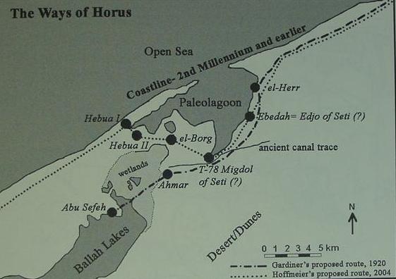
A certain man by the YouTube username of TaylorX04 has made a video called “Mountain of Fire Extinguished” which happened to use the above essay as a resource. For my take, see here.
Ok so Wyatt and Co are a bunch of hoaxters. Pity as I was all about to almost believe some of the preposterous stories I was taught as a kid. Ok back to the girnd disproving the entire bible as a fiction.
Well, I certainly do not consider the entire Bible as fiction; only the first few books (up to Samuel? Judges? Exodus?) and some books following (Esther, Daniel, Job, ect.). While the authors of the Bible often used plenty of fiction in their semi-historical accounts (Judges, Samuel, 1 Kings), there are a few Prophets (Jeremiah, Ezekiel) whose scribes rarely narrate, and sometimes record historically valuable information.
Mount Sinai must be in Midian.
1. It was in Midian, where God called Moses (Exodus 3:1, 4:19).
2. Hobab said (Num 10:30) “I will not go; but I will depart to mine own land”
First: “own” is not in the Hebrew text
Second: It only means that Hobab went back to his property. Only a part of Midian belonged to him, not whole Midian.
So the Bible states very clear that Mt. Sinai was in Midian.
I have already replied to this claim in detail in Section 2 of this very page. To repeat, Exodus 3:1 does not state Mt. Sinai is in Midian, and Exodus 4:19 takes place after Moses has returned to Jethro’s land from Mt. Sinai
Secondly, I have shown it is highly unlikely Mount Sinai is in Midian in one of the paragraphs below Section 7, but above the list of criteria for Mt. Sinai.
Please, before stating these inanities, read the page. I do not like stupidities here.
S hw d y xpln th cw (s) ngrvng n th stn tbrncls fnd t th bs f Jbl l-Lwz n Sd rb….? Ths rn’t Rmn n ntr, t sms th rly srlt hd nhrtd t frm n f th gyptn Gds.
Jbl l-Lwz hs cv nr th smmt whr n th scrptrs, vn th Prpht ljh sd t s rstng plc drng hs ncntr wth th ngels r Gd hmslf.. n cntrst, nn f th thr cnddts t b th rl Mnt Sn / Hrb hs cv.
n th scrptrs, t sys “crssng f th s” S s vst bdy f wtr….Nt rvr r cnl. S th nly wy t crss th s s thrgh Shrm l Shk => Rd S=>Mdn (Sd rb). Bcs thrws, th nly wy t pssd th Sn Pnnsl s thrgh th Sz Cnl nd tht ddn’t ft wht th scrptrs sys s “Crssng Th S”….W hv nly n s n th r nd tht s th Rd S…ftr t s Sd rb.
n th scrptrs, Gd sd tht h wll dlvr hs ppl t f gypt…Sn Pnnsl s stll prt f gypt (vrybdy knws ths). S f y r ny thr ppl wll sy tht Mnt Sn s n th Sn Pnnsl, thn y r cntrdctng wht th scrptrs sd…T F GYPT. dn’t rd th bbl mch, ‘m nt bbl schlr, t’s jst mttr f cmmn sns….Jst my 10 cnts…. :)
-De-voweled for your sanity. -pithom
Jesus motherfucking Christ, read the whole page before you comment! All of your claims have been refuted here, and it is not my responsibility to copy and paste the relevant parts from the main page to this comment.
To E. Harding — Your criticisms of Jebel el Lawz were brought to my attention today, and I’ve read over your posting. I worked for 10 years with Ron Wyatt whom you refer to as “some crazy, lying nut job who had a history of ‘visions from God'” — sigh — Ron Wyatt was merely a human being who spent 22 years making over 100 trips overseas wherein he seriously risked his life to try to unearth archaeological evidence to help people believe in the Bible. I managed Ron Wyatt’s 1st museum from 1994-1996 wherein I shared Ron’s documentation of 7 major biblical discoveries, all of which had solid evidence to support them. Over the years while working with Ron and since Ron’s passing in 1999 I have listened to every criticism, but I have not yet heard something that would stop me from believing in Ron Wyatt’s discovery sites. There will ALWAYS be room for doubt, that is just a fact of us living in this world 2,000-4,000 years after these major events took place — so without having a Time Machine, no one can be absolutely 100% certain of anything, which is why it is important for “faith” to be a part of our research effort in these matters. We “study to show ourselves approved of God,” and we do our best — which is exactly what I observed Ron Wyatt diligently do as he undertook his work. The whole world is awash with different opinions on everything under the sun, so it is expected that there will be multiple interpretations of any site and any evidence that comes forward — but everyone needs to understand that none of these biblical sites will be fully verified until we get to heaven and see God’s “instant replay” of the events that happened upon this planet! Accordingly, it is safer to NOT to be too dogmatic with “insisting” that we “absolutely know” where such-and-such is and who is “totally right” and who is “totally wrong” — you have chosen to negate everything pointing to Jabel el Lawz and stated you ONLY believe in the traditional site — and therein comes the “faith” and “spiritual discernment” aspect of the entire game… are you honestly going to spiritually side with Constantine’s mother and her early paganistic walk with God and then the semi-pagan Catholic Church’s endorsement of the Traditional site? Or can you open your eyes to the fact that God actually hid the real sites from those people so that the centuries would pass with people leaving those sites alone so they might be reserved to be revealed just before the End of Time? Everything is proving to be controversial and problematic on this planet — a million different ethoncentristic viewpoints exist — but remember, at the heart of it we are to have Love for others we disagree with… So instead of you writing your website and feeling comfortable to insult Ron Wyatt, don’t you think it would be better to try to actually be polite and caring and compassionate? You’ve spent a lot of time researching this material, but how much time have you spent getting to know Ron or the people close to him? I’m guessing that you never met Ron or had the chance to speak with him — well I did for 10 years — and he wasn’t a “crazy, lying nut job”! He was a simple, honest-hearted person who loved the Lord who undertook a very challenging work for the Lord, searching for things that won’t be truly verified until we get to Heaven. If Ron lied about things, then he won’t be in Heaven — but at the same time, if you persist in calling him a “crazy (he wasn’t), lying (only God knows) nut job (oh really?),” then frankly you’re also in danger of not making it to Heaven either, E. Harding. God tells us to pray even for our enemies (Ron was not your enemy), and to pray for those who even go so far as to kill us, but Ron Wyatt came nowhere close to ever doing any of that to you! So, you need to read up on some of the other things contained within the Bible, and let the Holy Spirit impress you with what should be your proper response to Ron’s discoveries… treat them with respect and patience, study them diligently, look for Truth, but keep an open mind and be willing to “wait” to make that final judgment. That is the route that will please God. Oh, and try not to write obscenities involving Jesus’ name when responding to “trying” people like you did in the previous message on this page — there are other ways to communicate your displeasure with people, and this seems to be something you need to work on, in both your response to Nuno, and your response to Ron Wyatt.
— Jim Pinkoski
Jim-thank you for your response. You should note I am an atheist and skeptic, so argument from eternal damnation does not have any convincing power over me. I do not only believe in the traditional site-I just think it’s the best candidate. I argue mainly from the evidence-not by argument from the man, or from authority. While it is true I called Ron Wyatt a crazy, lying nutjob, that statement can be substantiated, and, in context, does not add to my anti-Lawz argument, but, rather, demonstrates the hypocrisy of those who claim that, since Constantine claimed to have visions from God, his mother’s candidate for Mt. Sinai should be discounted. Even if Ron Wyatt was the most moral person on Earth, if he was mistaken, he would be mistaken.
Mr. Harding, if you are an atheist, why would you even care about where Mt. Sinai is?? You seem to have invested a lot of time delving into religious subjects, you say you “believe” that the Traditions site is the real Mt. Sinai — and you’re an ATHEIST?? An atheist wouldn’t care at all about where Mt. Sinai is! You are definitely a skeptic, but I am mystified how you can claim to be an atheist… MT. SINAI IS WHERE GOD CAME DOWN AND WROTE HIS LAW, so why would an atheist spend so much time verifying the biblical location and concluding it IS the real Mt. Sinai?? What do you conclude happened at Mt. Sinai? If you don’t believe in God, then WHO came down onto Mt. Sinai???….
Hi Jim,
It’s simply the adversary using people (like in this case). We have arrived at the end of the “Times of the Gentiles”, which was foreshadowed by Nebuchadnezzar’s insanity – so why should we expect differently? The enemy has very little time left and it’s just natural that he employs particularly the academia to poison people’s minds (in the guise of an objective, evidence-based approach – free of the subjectivity of faith :-)
I just got back from Jebel Maqla, and of course it’s the biblical Mt. Sinai, and of course it needs to be demonized (that’s the job).
H, ‘v bn rdng yr crrspndnc. Rn Wytt wsn’t lyng nt jb. nt tht t hs blcknd tp s cnfirmd b svrl dffrnt ppl ncldng Bb Crnk, frnd f th nw dcsd strnt Jm rwn. ccrdng t th Bbl, Mt Sn ws n fr nd smk cm frm t. Ths s nt t b fnd t th trdtnl st, whch ws dsgntd s th st b slf-prclmd sr, Hln, wf f Cnstntn. Sh dsgntd thr sts s wll s th trdtnl tmb f Chrst’s dth nd rsrrctn. W nt tht, thr, t ths st, thr s n clr rfrnc sch s Glgth. Hr sr blts, s n cn tll, r npt. Snc Jbl l Lwz prmtr 1. hs lrg splt rck wth vdnc f lrg mnts prsn vdncd b th srrndngs 2. Hs blcknd tp s mntnd b scrptr. 3. n sqr shpd ltr nrby wth pctrs f hthr nd ps cws dpctd. 4 clmns. 5. ndctns f rvr flwing frm t. 6. n rly rfrnc t n rly trvllr n th r wh thght t cld b Mt Sn, m cnvncd tht ths s th rght st. t’s th mnt f cmpllng vdnc. Th bg qstn mrk hs bn thrwn n th trdtnl st nd lwys bn thr. Wh wld th srlts scp t n r tht ws clrly mnd nd ccpd by gyptns? Yr clms tht Wytt ws lr s nt brn t by th vidnc. Wytt dd nt lk t rspnd t hs crtcs, s, fr th lrg prt h nvr dd. Bt pn m wn prvt nvstgtn, pn hrng tp tht wsn’t rlsd t th pblc, cm t b wr tht ppl wr lng bt Rn Wytt nd knw ths frm rcrd tlphn cnvrstns tht tld dffrnt str. hv ls tlkd t sm f th crtcs f Wytt nd skd thm qstns n rgrd t thr sttmnts nd hv fnd thm wntng. S nlss y d tht mch rsrch wld hv t cll nt qstn yr pnn. Y s, gttng t th fcts nd hrng pnts f vw frm LL prts s wht rsrch s bt.
-You haven’t learned, have you. Learn to read the page, not the correspondence. All your concerns are addressed there. Also, what is the “early reference to an early traveller (sic) in the area who thought it could be Mt Sinai” you are referring to? What were the false accusations of the anti-Wyattists you heard?-pithom
I too met Ron Wyatt, both by many phone conversations, and in person. He was a respectable man who was very sincere about serving God the best he could.
I have followed his research since the early 90’s, visited the museum, and found the findings to be credible and consistent with the Bible. The sad thing about the conclusion that these findings are false is that, as you can see by some of the posts, it drives people away from the God who arranged for us to see them and believe.
Perhaps, that is a good thing. Fundamentalism is never good.
Jim, I myself am mystified by my interest in ANE history. It all started when, already an atheist, I started studying the Bible (just to see what it’s all about). Then, that studying spiraled out of control to form the person who writes this blog. I truly wish I did not have this constant desire to know more about ANE (especially Israelite/Judahite) history, as I could get much more work done if I did not have this urge to constantly know more about the world that formed the Bible. I believe Mt. Sinai was a mountain which might have started off as a Judahite or Israelite religious concept (c.f., the Kuntillet ‘Ajrud ostraca’s “YHWH of Teman”), possibly the traditional place of the origin of the Shiloh Tabernacle, which eventually became identified with Ras Safsafeh by early-mid 8th C BC Judahites who interacted with the Sinai Bedouin after beginning to actively participate in the Arabian trade by way of Kuntillet ‘Ajrud.
Sounds like your belief about how the idea of a “Mt. Sinai” getting started in ancient Israelite thought is just as speculative as you claim Mr. Wyatt’s claim is.
Perhaps, though not as historically improbable. I know of no better hypothesis.
Why does my message appeared to be hacked with missing letters?
As a punishment for your not reading the entire page.
Additionally, the “blackened rock” is not varnished. A cross section goes threw the entire rock. The “expert” had no sample of the rock and threw out speculation as fact.
Did you not read my mention of the dark bluish-greenish rock being over-710-million-year-old amphibolite?
Was it not rather around 690.56749 years?
I won’t debate with academic fools. I have got a piece of rock from the summit of Jebel Maqla (just got back).
Maybe I have it analysed, but since the result won‘t make a difference, I may, on second thoughts, leave it altogether :-)
It’s blackened for about 1 inch, and the colour of the rock turns beige.
The date of the “dark bluish-greenish rock” isn’t something I heard brought up by Wyatt. However, the black obsidian is. There is no contest that this isn’t varnish. There is a mountain where I live that does have the varnish that this “expert” contends exist, but he is dead wrong when it comes to the blacked top of Jebel Al Lawz. Further, green glass was found at sites heated by atomic bombs. Sand at extreme temeperatures. Maybe this bluish to green that you call amphibolite is of a heated process. However, to date it is speculative as you cannot use a time machine to test a dating method.
I know of no evidence of expert-analyzed “black obsidian” at the top of Jebel Maqla. As for the dating of the rock, ask the author of the bbs.keyhole post I mention at the end of the “Blackened Peak!” sub-section.
Let me clarify how I have studied all of the criticisms against Ron Wyatt (whom I worked with from 1989-1999) — you’ve mentioned the book by the Standish brothers wherein they criticized everything Ron ever claimed, Holy Relics or Revelation — I read that book thoroughly, I was even mentioned in it 8 times — my conclusion was that there was only ONE criticism in that book that was credible (it dealt with the sign placed above the cross in 3 languages, but at the same time it did NOT negate the possibility that Ron Wyatt located the crucifixion site) — I wrote a 50-page pamphlet reply to the Standishes, and they chose to ignore every single thing I said! That is the way it is with these things, people use their free will to pre-decide and then refuse to listen further — it was the same way with the “Tentmaker” critic, at first he supported Ron’s discoveries, then he was swayed by the criticisms, then he refused to listen to any of our replies! In my discussions with him I found out that he believes that “everyone will be saved” and no one will be lost — so right there I know that he does NOT know how to read the Bible, because it is as plain as day that the Bible says that some will be saved and others will be LOST! So how can I trust that “Tentmaker” can do a reasonable job of studying and interpreting Ron Wyatt’s material?? He can’t! And this is the mess that Ron and all of us who worked with Ron have had to deal with these past 45 years since Ron started his work in 1977, we are living near the End of Time and the human race has been deteriorating for the past 6,000 years and people’s brains DON’T work right…
Jim, I did once cursorily read your review of the Standish book on the web.archive, but I did not find you very open-minded or convincing there. I’ll have to find that review again. Also, I am an atheist-arguments from eternal damnation do not resonate with me at all. The world has actually gotten quite a bit better for humans over the past six thousand years.
Found it!
Well, that’s nice to see that my “Holy Relics”reply webpage is still accessible online! The Standish brothers considered themselves to be the self-appointed guardians for all Truth within the Adventist Church and they prided themselves on their “superior spiritual discernment,” which was why it was so disappointing for them to ignore pretty much ALL of my replies — (one of their most glaring errors was telling GOD what He can or can’t do regarding Jesus only having 24 chromosomes, what arrogance on their part to “insist” THEY knew it can’t happen that way…what a totally stupid and blind thing for them to ever say…) — like so many other “impatient” people, they wanted “instant proof” for Ron Wyatt’s work on the Ark of the Covenant dig, and they became offended when Ron said he could not and would not provide it at this time (it will only be shown to the world in GOD’s timing) — they were offended by this, and they were impatient, and then they opted to look for things to doubt regarding all aspects of Ron Wyatt’s discoveries…
Yes, in a way things have gotten “better” for mankind these past 6,000 years regarding mankind’s better understanding of the sciences, medicine, and our modern conveniences — but look at the actual condition of the human race: millions of people are obese and borderline diabetic, everyone’s tempers are on edge because of the overload of modern society, the intensifying of various groups of people “insisting” they are the only group who are right and they have no patience for other people’s views or opinions… all of which is contributing to the eventual destruction of the human race as Time continues!
Ron Wyatt was a Seventh-day Adventist, as am I, and many of the people who have continued to work with Ron’s discoveries — one of our “beliefs” is that mankind has been deteriorating since Adam and Eve were expelled from the Garden, and if the Lord does not return with His 2nd Coming by a certain time the entire human race would die off because of their inner deterioration of Life energies… and this deterioration process also is affecting mankind’s ability to think and reason and discern spiritual Truths…
You say you’re an atheist, yet you deeply study biblical topics and “contend for the truth” — this is a sign that you are still interested in finding GOD, and He is interested in having you find Him! True atheists don’t care about the Bible at all — when I made my decision to accept the GOD of the Bible, I had spent many years investigating many religions and belief systems — first and foremost, I KNEW that some version of GOD was out there — and then after I studied all the belief systems, a series of events fell into my Life that clarified exactly “which” version of GOD I should focus upon… so you may think that you’re a confirmed atheist, but GOD may have some surprises in store for you, pithom.
A Christian website advocating a Nuweiba crossing and a location for Mt. Sinai at 27°51’29″N, 35°44’32″E has rebuked my claim that the et-Tih road was too rough for chariots to travel upon. I have updated the main page to clarify my position.
I started to read your blog and immediately sensed that: 1. You had an agenda. 1.5 that you were biased. . However, the Holy Grail appeared when you stated that “Paul’s use of ‘sustachios’ does not NEED to be taken literal”. WHAAATTT?? Who are you to decide that? Do you use any examples that could back up your hypothesis? LOOK, you are not being honest with yourself or the others and I feel so bad that some’s lack of reading skills (and intelligence) fall for such a propagandist research paper. However, Jesus said: “Do not throw your pearls over to dogs” You my friend, are a waste of time. The fury that your lying causes me is actually offseted by the understanding that you will rott in hell and that your disciples, those who are swayed by your lies, are not worthy of the truth either. I hope you don’t delete this comment either. Thanx.
As I am merciful, I will approve this comment. In short, as demonstrated by Allen Kerkeslager, the word “sustoichousa” was replaced with “sustoichei” sometime in the late 2nd C BC, after the interpolation of “Arabia” into the text of Galatians 4:25. Thus, Paul’s use of the word must have been meant in a figurative sense. If I am “a waste of time”, then why bother to comment on the blog that I am the sole contributor to? Also, if one is angry at a certain idea, one is almost certainly not viewing it objectively. I have no disciples, and you have not demonstrated there is a single lie in this piece of writing. This piece of writing is not propagandist and I am being quite honest with myself. I am not biased here, and I remove any piece of bias I happen to find here. Also, this is not a “research paper”, but a webpage.
Having looked at the itinerary of the Cof I as given in Exodus, it seems that the following is true, or at least highly arguable.
They left Egypt and headed across the Sinai peninsula to the Yam Suph, ie Aqaba crossing, as Wyatt states and Glen Fritz agrees. ( see link in my earlier post.) This was so that God could show His great power, and discomfit the Pharaonic host.
They then turned north, towards Shur, as everyone places it. This would be heading towards Canaan via the wilderness of Sin. But something happened at Marah; they showed by complaining that they didn’t trust the God who had just liberated them. So God judged them. Next stop was Elim, and then the W of S, but here is the important bit, Sin is between Elim and Sinai, as we are unambiguously informed. So instead of continuing north, they were now going south. God gave them manna and quails here. Next He appeared to them at Rephidim at the Mountain of God , or Horeb, and gave them water. This place is in the orbit of the Amalekites, with whom they fought, so it needs to be north of 30′ and east of 34′, but probably even further north east.
Jethro appears and disappears.
We next hear about Mt Sinai, which could lie either in its recognised locus, or, quite conceivably, in Midian. The fact that God had already appeared top Moses there makes it, in my opinion at least, and for the present at any rate, the more likely candidate.
Why would the C of I go as far West as the Wilderness of Shur when going from the Midianite coastal plain? The Wilderness of Shur is not mentioned in any of the journeys of the C of I in the Aravah or the area of Kadesh-Barnea (on the roads between Canaan and Midian), strongly suggesting it is in the W. Sinai, off the road from Midian to Canaan. Why are Edom and Eloth not mentioned between the sea crossing and the journey in the Wilderness of Shur? The Horeb of Exodus 3 is not necessarily in Midian; see Section 2 of this page. The Amalekites do not necessarily need to be in North Sinai; they could have inhabited South Sinai.
The first & main problem of most of those who are looking for Mount Sinai/Horeb is that they believe the Exodus story happened exactly as described in the Bible, and that they read it as one coherent story – while, in fact, it’s a late story (mostly false) that was consisted of two different ancient traditions, originating from two different groups of people:
1) The ancient tradition of “Escape from Egypt” which originated in a group of Semites who escape from Egypt at the end of the Hyksos period (~1570 BCE) and who were already settled in the area of Shechem (where they developed the first versions of the Joseph & Exodus stories – and worshiped the Canaanite “El Shaddai” in the form of the bull [“calf”]) throughout the entire Late Bronze period.
2) The ancient tradition of “Wandering in the Desert around the Holy Mountain/s of Yahwah” which originated in a group of “Shasu” nomads – also known as “The Shasu of Yhw” as they are mentioned in Egyptian toponymical lists from the Late Bronze.
Those two different groups only met for the first time when the “Shasu” nomads from the desert started migrating into the central highlands of Canaan at the end of the Late Bronze, around 13th-12th centuries BCE – and only at that point they started the long (and sometimes bloody) process of fusing their two different gods (“El” and “Yahwah”) and two different traditions of “”Escape from Egypt” and “Wanderig in the Desert around the Holy Mountain/s of Yahwah”…
When we read the story as it is in the Bible today, it’s easy to fall for the claim that the “Israelites” came out of Egypt, “Crossed the sea” (originally part of the “Escape from Egypt” tradition – and it has nothing to do with the Red Sea [it actually says “Sea of reeds” in Hebrew] but never mind) – and immediately started wandering through the desert on their way to Mt Sinai. However, even some of the earliest modern Biblical scholars, like Gerhard von Rad and Martin Noth, have already noticed the many clues that suggest that these are two different traditions that were fused together at a late stage (for example see: Martin Noth, A History of Pentateuchal Traditions [1972 English translatin], pp. 59 – 62)…
In short, anyone looking for Mt Sinai/Horeb doesn’t need to take in to consideration the entire “Escape from Egypt” story. All he needs to do is look for some “Holy Mountain/s” – either in north Arabia or north Sinai – where there are evidence for nomads activity in the Late Bronze Age (and finding some inscription that says “Yhw” on a stone there would be a great step forward in terms of a proof)…
Finally, a reasonable comment on this page. I am aware of the Mattfeld view (which you seem to have adopted), and it has begun to look ever more reasonable to me as I have been unable to find a superior explanation for both the origins of the Exodus or Wandering traditions. The only mountains where there is solid evidence of Late Bronze religious activity are Serabit and Timna. I’m still uncertain of the origin(s) of the sea-crossing tradition-as I have pointed out above, “Yam Suph” was a term applied both to Lake Ballah and the Gulf of Aqaba, the latter being used as a sea route by the Egyptians in the later Late Bronze to transfer copper from Timna to Egypt.
Thanks for the compliment… As a former student of Archaeology and Biblical Studies, I am embarrassed to say I am not familiar with that “Mattfeld view” you have mantiond – could you please elaborate?
What I wrote here was my own synthesis of many discoveries and theories that I read about over many years of interest and studies (I read people who said similar things about the different aspects of what I presented above, but it’ll be nice to see someone made the same synthesis as I did).
About the sea-crossing tradition and mount Sinai – I’ll come back to write here latter, I’m a little short in time a the moment…
The view propagated by Walter Mattfeld at bibleorigins.net . Don’t be embarrassed- Mattfeld is a mostly competent amateur who heavily relies on scholarship, not a scholar. He has not published a single peer-reviewed paper on any of the relevant topics, though he has written many web pages on them.
Thanks, I feel relieved. I’ll try to check out his web site later.
About the miracle of the sea:
To me it is obvious that the story of the “miracle on the Sea” in Exodus 13 – 14, is consisted of two or more sources (probably Sources E and J, with addition of P and / or intervention of the editor). Only one of these sources talks about “Yam Suf” (with the Israelites camped at “Etham”), while the other is talking about “Pi Hahiruth, between Migdol and the sea” (with the Israelites camped “opposite Baal Zaphon”).
According to the first story, which talks about “Yam Suf” (which I think is actually the latest version of the two), Pharaoh sent the people of Israel voluntarily , then changed his mind and pursued them, so then Moses struck over the sea with his staff, the sea opened into two parts and the Israelites crossed in the middle, and then, when the Egyptians tried to follow them, Moses struck over the sea with his staff again and the two parts of the sea closed over the Egyptian pursuers who were stuck in between…
According to the second story (which I think is the more ancient version of the two), the people of Israel actually fled from Egypt (“When the king of Egypt was told that the people had fled” [Exodus 14:5A]) and camped at “pi Hahiruth, between Migdol and the sea – opposite Baal Zaphon” (probably some place in North East Delta or North Sinai [Zaphon = North] on the coast of the Mediterranean sea). At that point, when the Egyptian pursuers got close to them, the “angel of God/pillar of cloud”, who traveled in front of the Israelites, withdrew and went behind them “between the armies of Egypt and Israel” and brought “darkness” on the Egyptians. Then “God drove the sea back with a strong wind and turned it into dry land”, then he “looked down from the pillar of fire and cloud at the Egyptian army and threw it into confusion”, at this point the Egyptians said “Let’s get away from the Israelites! The Lord is fighting for them against Egypt” and started running toward the area of the sea that was still dry, and then, at that point it is said: “at daybreak the sea went back to its place. The Egyptians were fleeing toward it, and the Lord swept them into the sea”…
As i said above, I believe that the second version is the more ancient version. It deals mainly with “God fucking up the Egyptians – who ended up lying dead on some shore” (Exodus 14:30) and the greater miraculous idea of “the Israelites crossing the sea in the middle” is still absent from it. In fact, you can actually see that the idea of the Israelites crossing the sea was only added as some kind of “footnote” at the end of the “Song of the Sea” (Exodus 15:19), and in the Book of Joshua you can still find an entire lecture on that “miracle of the sea” that only mentions the second version above, with no miraculous “Israel crossing the see” motif (Joshua 24: 5-7)… However, since “Yam Suf” is also mentioned in both “Song of the Sea” and Joshua 24’s lecture, I can only speculate that it was added as part of the earliest attempts to combine the “Escape from Egypt” tradition with the “Wandering in the Desert” tradition (obviously, both the “Song of the Sea” and Joshua 24 are part of such attempts) and, therefor, it is possible that “Yam Suf” was first added as an element which was aimed to describe the “turn in the road” that the Israelites allegedly took in order to turn South-East (into the “Wandering” tradition) instead of going straight to Canaan through the coast-road as any real people must have done (See the anachronism: “When Pharaoh let the people go, God did not lead them on the road through the Philistine country, though that was shorter. For God said, “If they face war, they might change their minds and return to Egypt.” So God led the people around by the desert road toward the Red Sea” [Exodus 13:17-18]), and only sometime after the element of “Yam Suf” was introduced, someone must have come up with the second great idea of “crossing it in the middle” (something that was completely irrelevant in the original version which was talking about “Baal Zaphon” on the coast of the Mediterranean sea).
As for any real historical event that might possibly lay in the basis of this tradition: Maybe it has something to do with that great catastrophe mentioned in the Tempest Stele (alt. “Storm Stele”) of Ahmose I – and/or with the Santorini Eruption (although the dating is problematic) – of course one can’t be sure in such matters… :)
About the subject of Mount Sinai:
Maybe we should follow the trail of the “Midianite pottery” (“Qurayya ware”) as described by Rothenberg, Beno and Jonathan Glass (1983). If we do so, I’m sure that on our way we’ll find many high mountains that spread all over the vast area between Qurayya in the Hejaz (northwestern Saudi Arabia), southern and central Jordan, southern Israel, and the Sinai desert… Anyone of those mountains might have been “Holy” to someone at some point, and I’m sure that there are many sites that we have yet to discover…
I suggest we keep waiting patiently for that “Jehovah” inscription I’ve mentioned before… :)
While the hypothesis of Baal Zephon being the shrine at Mount Casius on the shore of Lake Sirbonis does explain the references to turning back and “between Migdol and the sea” better than I have explained them (with the Migdol of Exodus now allowed to be the same as the Migdol of Jeremiah and Ezekiel), renders my “two Seas of Reeds” hypothesis superfluous, and (when combined with your hypothesis of a separate origin for the sea crossing narrative) also does a fine job of explaining Exodus 13:18, I still find the chronology of the developments of the two traditions you have hypothesized to be problematic, especially given the likely 7th C BC origin of both the Mount Casius shrine and the renewed Migdol, though the additions of the “Yam Suph” references to the Song of the Sea and Joshua and the development of the sea crossing tradition might have taken place during the Exile (or just later). As for the Santorini eruption and the Tempest Stele (two unrelated things), see the excellent review over at Higgaion. I now think Serabit al-Khadim holds the most promising origin for the Sinai tradition, especially given that a Jebel Ghorabi and a Jebel Saniya exist there.
Look, trying to identify places called “Baal Zaphon” and “Migdol” in ancient Egypt is like trying to identify a specific person who goes by the name “John Smith” in the Wild West… We know plenty of “Migdols” existed in north Egypt even at the time of Seti I, and we know “Baal Zaphon” was a familiar deity in Egypt even at the time of Ramses II.. To identify such places, and then try to date the biblical writers according to the findings there, seems dubious to me…
In general, I must say, I find all that “late dating” hard to accept. Source E, for example, is far too well connected to the northern kingdom of Israel – Which expired around 722 BCE, mind you… But, again, I’ll have to come back to you on that later… :)
I only know of one New Kingdom Migdol in the NE delta. I also do not know of any certain evidence of a Third Intermediate Period Migdol in the NE delta, though the existence of such a place is not out of the question, as Site T-78, the most likely site for the Migdol of the New Kingdom, has been covered over with many feet of soil and has, thus, not been excavated (see this video, esp. at the 54:30 mark). I still say that if the sea of Exodus 14:2 is the Mediterranean, Tell Kedua (30°58’60″N, 32°28’31″E; the most probable site for the Migdol of the 26th Dynasty) is the best-fitting Migdol in Exodus 14.
See “Tkw” (Sukoth?) “Htm” (Etham?) and “Migdol” – as a route of escapping slaves – in Papyrus anastasi V, from the time of Seti II…
I still see no evidence for a New Kingdom Migdol other than Site T-78. Htm is probably not Etham-“Etham” begins with an aleph, not with a heth. I agree that Tjeku/Tkw is very likely the biblical Succoth.
Are you talking about that Site:
http://www.biblearchaeology.org/post/2008/08/new-evidence-from-egypt-on-the-location-of-the-exodus-sea-crossing-part-ii.aspx
OK, so what’s “late” about that? In fact, if Site T-78 is the actual “Migdol” of Seti I and the one mentioned in the Exodus story, then it could make this “route of escaping tradition” even more ancient than I imagined in my wildest dreams… Up until now I just thought that all the “pinpointing of locations” element in the story was added only at the time when the first versions of source E stories were written – probably in the Kingdom of Israel between the 10th and 8th century BCE… Before that, so I thought, there were only popular stories which described the “miracle on the sea” in general – without bothering to elaborate on such “educated details” – but now, who knows…
I agree with you that “Htm” is far from “Etham”… Furthermore, in second thought I must add that, anyway, both “Etham” and “Sukkoth” are not part of the route described by the more ancient (E?) source (which only mentions “Pi Hahiruth, between Migdol and the sea – opposite Baal Zaphon”)… Both “Etham” and “Succoth” appear to be part of the later version – and now I’m starting to think that this version actually might belongs to Source P rather then Source J, because of the typical “mathematical” P sentence: “The Israelites journeyed from Rameses to Sukkoth. There were about six hundred thousand men on foot, besides women and children” (Exodus 12:37)…
By the way, did you note that both articles – the one you referred me to about Serabit al-Khadim (most interesting! I didn’t know about Jebel Ghorabi and a Jebel Saniya!) and the one dealing with Seti’s Migdol above – are not aware of the fact that they are reading two different Sources with two different route descriptions, and that it could be that the original “Escape from Egypt” tradition might had nothing to do with “Mt Sinai and Wandering in the Desert” tradition?
Nothing (as far as I know) is certainly “late” at Site T-78 -it has not been excavated, nor will it be anytime soon. I am generally uncertain (and thus, skeptical) of source-critical reconstructions (as I have not studied them in depth), though there are clearly some combinations of sources in the Bible (e.g., the account of Sennacherib’s campaign in 2 Kings, where three independent sources can be readily distinguished on grounds of internal consistency and realia mentioned in the account). Walter Mattfeld, for example, believes that a single Exilic author composed the entirety of Genesis-2 Kings. I find this idea to be somewhat implausible (there were certainly later additions, and I suspect the whole idea that the Patriarchs originated in Mesopotamia was developed in the Exilic or Persian period). There might be different (independent?) sources behind Exodus 13-14, though I am uncertain regarding the matter of their existence.
Indeed, we can’t be sure that Site T-78 is in-fact the “Migdol of Men-maat-re” mentioned in Seti’s Karnak relief of his campaign to Canaan. However, based on Seti’s Karnak relief alone, we can be sure that such “”Migdol” had existed in his time, at least (but the place and/or the name might have also been preserved in later periods too), as a third fortress along Egypt’s Horus Way, which was part of the Coastal Highway – and, therefore, might have provided an ancient basis for that mentioning of “Migdol” in the early Exodus story…
As for Source Criticism – I strongly recommend to start studies with Richard Elliott Friedman’s popular book: “Who Wrote the Bible”. Although the book is a bit simplistic and some of Friedman’s conceptions there are probably wrong, I think it presents the main case of Source Criticism in a convincing way (though, probably, the claims must appear more obvious and the evidence much more compelling for those who are fluently reading the Bible in the original Hebrew)… of course, the Sources “thing” is much more complex than just having 4 documents (E, J, P and D) which were written by 4 different scribes – each in a specific narrow timeline – and then edited into a combined version by some later editor. Obviously, in some Sources (for example P and D) there are more than just one writer and there are different stages of writing that took place at different periods of time (mainly pre-Exilic and post-Exilic); and, of course, in most cases, the “Sources” themselves are relaying on earlier sources (either written sources, or ancient Oral traditions) – sometimes even quoting them directly (as In the case of Jacob’s blessings, Song of the Sea, blessings of Bilaam, song and blessing of Moses, etc) – and, of course, there were more than just one editor and one stage of editing…
Given the complexity of the scriptures, I can easily understand anyone who rejects the Classic 4-Documents/4-Sources Hypothesis and claim that the Bible was just composed of dozens of different documents and stories, collected and/or written by different authors over a long period of time… However, anyone who looks at the Bible and presumes that “a single Exilic author composed the entirety of Genesis-2 Kings” is apparently reading a completely different Bible from the one I read…
About the “idea that the Patriarchs originated in Mesopotamia” – it’s a long story (in fact, two stories – as usual… ;-)), and once again, my time is short at the moment… :)
Due to the fact Site T-78 is between Tell el-Borg (a name which may, curiously, preserve the name “Migdol”), the next major site after the southern part of Tjaru, and, thus, most likely the Dwelling of the Lion, and Tell Ebedah (the Udjo/Buto of Seti I), I think the identification of Site T-78 with Migdol is very safe. I read “Who Wrote The Bible?” some time ago, and still own a copy of it. I found the maximalism in regards to Solomon (which forms a crucial part of Friedman’s understanding of the E source) somewhat off-putting due to the high probability Solomon was not a powerful king, but merely a petty ruler of a small, sparsely populated Jerusalemite kingdom. Of course, an 8th C BC E source is not all that implausible.
Also, I am not all that confident of R.E. Friedman’s abilities to find textual sources-he showed no sign of being able to detect the sources behind the Biblical account of Sennacherib’s campaign in pages 93-96 (of the paperback of the 1997 edition)! The case for his ideas regarding two editions of Deuteronomy and the Deuteronomistic History is very persuasive, though his case for the idea that they were both written by the same author (much less Baruch ben Neriah!) is not. His dissection of the flood story is not persuasive, especially when one gets to Genesis 7:6 and onward-is it all that likely that an author writing on scrolls could hold three of them in place at once? I understand switching scrolls when copying blocks of text, but not when copying snippets!
Oh boy, Am I glad to hear you don’t like Friedman! I just went through his Sources list today, and it completely shattered that little thesis I was starting to build up here above… :)
According to his list the location in “Migdol” is in fact part of the same story (written by P!) as the “Crossing of the Sea in the middle, with Moses’ magic wand” (while the other elements in the story belonging either to E [“Yam Suf”] or J [the “tsunami” element])…Reluctantly I must admit that at least in regard to P, his reconstruction is better then mine. Indeed, one can see the continuity in the text – even if it does look weird on the map:
“[Ex 14:1]Then the Lord said to Moses, [2] “Tell the Israelites to turn back* and encamp near Pi Hahiroth, between Migdol and the sea. They are to encamp by the sea, directly opposite Baal Zephon. [3] Pharaoh will think, ‘The Israelites are wandering around the land in confusion, hemmed in by the desert.’ [4] And I will harden Pharaoh’s heart, and he will pursue them. But I will gain glory for myself through Pharaoh and all his army, and the Egyptians will know that I am the Lord.” So the Israelites did this.
[8] Then the Lord hardened the heart of Pharaoh king of Egypt, so that he pursued the Israelites, who were marching out boldly – [9b]by the sea near Pi Hahiroth, opposite Baal Zephon.
[10a]As Pharaoh approached [10c] the Israelites cried out to the Lord.
[15] Then the Lord said to Moses, “Why are you crying out to me? Tell the Israelites to move on. [16] Raise your staff and stretch out your hand over the sea to divide the water so that the Israelites can go through the sea on dry ground. [17] I will harden the hearts of the Egyptians so that they will go in after them. And I will gain glory through Pharaoh and all his army, through his chariots and his horsemen. [18] The Egyptians will know that I am the Lord when I gain glory through Pharaoh, his chariots and his horsemen.”
[21a] Then Moses stretched out his hand over the sea, [21c] The waters were divided, [22] and the Israelites went through the sea on dry ground, with a wall of water on their right and on their left. [23] The Egyptians pursued them, and all Pharaoh’s horses and chariots and horsemen followed them into the sea. [26] Then the Lord said to Moses, “Stretch out your hand over the sea so that the waters may flow back over the Egyptians and their chariots and horsemen.” [27] Moses stretched out his hand over the sea, [28] The water flowed back and covered the chariots and horsemen—the entire army of Pharaoh that had followed the Israelites into the sea. Not one of them survived. [29] But the Israelites went through the sea on dry ground, with a wall of water on their right and on their left.”
*by “turn back” (וְיָשֻׁבוּ in the original) I presume the writer was aware that according to the route he described earlier in the text, the Israelites were first heading south – from Raamses to Sukkot and from Sukkot to Etham “on the edge of the desert” – and that now they are “turning back” to the north, making such a route which will make Pharaoh think: ‘The Israelites are wandering around the land in confusion’…
Well, if that is the case (and it probably is), then we can assume one out of three:
1) P is describing real events and a genuine route of the real Exodus (Yea! Right!:));
2) P (as a descendant of “Aaron’s family” – who, at some point of history, probably worshiped Canaanite “El” in the form of bull/calf) is trying to settle some ancient and confusing tradition/s which existed before his time (just like he is doing in Exodus 6: 2-3 [“I am Yahwah. I appeared to Abraham, to Isaac and to Jacob as El-Shadday but in my name Yahwah I was not known to them”]);
3) P, which is well known for his obsession with boring details, couldn’t just leave the story without elaborating on such “important details” as the route of escape, so he invented his own story and rout, based on anachronistic details known in his time/s (8th – 5th century BCE?).
I guess it’s either 2 or 3 (or some mixture of both), but yet, even with excluding P stories of Exodus as something to relay on, I still think that the tradition of the “Miracle of the Sea” (in the original form, which was probably closer to the “tsunami” version of J or E) was part of the “Escape from Egypt” tradition – and not part of the “Wandering in the desert & Mt Sinai/Horeb” tradition – for furthermore important reasons, on which I’ll elaborate next time I’ll find some time (hopefully in 12 – 24 hours)…
Darn! And I thought the Mediterranean tsunami idea made better sense of Exodus 14:2. The idea of a sea crossing is hard to reconcile with the placing of the destruction of the Egyptian army at the Mediterranean. I still don’t know which reconstruction of the original meaning of Exodus 13-14 and/or the possible sources behind it fits better with the real geography of the NE Delta/NW Sinai-a Lake Ballah crossing (which leads to the reconstruction in Section 6 of this page) or a Mediterranean ‘tsunami’, which allows one to identify Migdol and Baal-Zephon with clear Saite and/or Persian toponyms.
Hello Pithom,
I would like to introduce an aspect of the exodus route that I have not yet come across concerning the following passage –
“And it came to pass, when Pharaoh had let the people go, that God lead them not through the way of the land of the Philistines, although that was near, for God said, Lest peradventure the people repent when they see war, and they return to Egypt. But God led the people about, through the way of the wilderness of the Red Sea…” (Ex13:17,18)
The point I will be making is that when the Israelites left Egypt they had no intention of travelling to Mt Sinai (wherever that may be) but were heading for the region south of Canaan. The most obvious route to Canaan from the western delta region of Egypt is ‘the way of the land of the Philistines’, an arrow straight(ish) route running along the coast of the Meditteranean Sea but this was discounted, not because it didn.t take them where they wanted to go (it obviously did or it would not have been mentioned) but because it was ‘too straight’ and would allow the Israelites to simply turn back when it dawned on them that Canaan was not to be ‘given’ to them but that they would have to fight for it.
The whole point of taking them ‘through the way of the wilderness of the Red Sea’, including the crossing, was so that the Israelites could not find their way back to Egypt in the event of war.
The route of the exodus was not made up ‘on the hoof’ as it were, the plan was to get this mass of people from Egypt to the area including Kadesh Barnea and from there to make their assault on Canaan. The main feature of the route taken was so that it would make it impossible for the Israelites to turn back.
The reason they ended up at Mt Sinai was the defeat at Rephidim (the text provides very strong clues that Rephidim was near the Aravah). Mt Sinai was a place of retreat, a plan B. If the Isrealites had been victorious at Rephidim they would have carried on up into Canaan but as it was they were forced to regroup.
I am aware how many questions this tentative proposal begs and would like to test it with your help. I carve nothing in stone and enjoy the flexibility of someone still learning and who understands the difference between ‘the truth’ and a ‘best fit’.
Jebel Lawz aside, I find a number of reasons I cannot accept the “Jews wandered in the Negev 40 years “theory.
Example :Exodus 23:31″And I will set thy borders from the Red Sea, to the sea of the Phylistines, and from the wilderness to the great river Euphrates; and I will give into your hand those that dwell in the land, and will cast them out from thee.”
So, the southern border of the Promised Land extended “Red Sea, to the sea of the Phylistines”
That of course includes the Negev…so the Hebrews wandered for 40 years…supposedly in Exile, in the very land they were forbidden to enter!.
Hmm. A true “Jump the Shark” moment.
Let’s see, God did not lead them “by the way of the Philisitines” “lest they see war”….
But there they were, Kadesh Barnea only 20 miles from the Philistine border, a few miles from Shahuren, capital of the Amalekites, a short distance from Arad…
Yet they wandered unopposed for 38 years.
Hard to swallow that one. Especially since only a few months latter Joshua takes 29 cities in the Negev by war.
Where were those cities during the Exodus?
Cities mean people, farms, water….so why was it the hebrews couldn’t find water when Archeologists tell us the Negev in the Bronze Age had a relatively large population.
Oh yes, and with this theory MOSES is about the one and ONLY Hebrew who dies and is buried OUTSIDE the Holy LAnd.
Miriam gets to be buried in land Joshua gives to Simeon, Aaron in land Joshua gave to Judah.
Poor Moses is shown the land he could not enter from Mount Nebo…which happens to include the Negev where he’d just spent 38 years.
That must be one of God’s “oops” moments….wrong slide in the projector.
Right?
God tells Moses he cannot go to the Negev when he’s spent a third of his life there?
Did anyone notice the obvious here? The Hebrews wandering in the Negev DID NOT NEED TO ASK EDOM FOR PERMISSION TO PASS…They were ALREADY in the Promised Land…all they had to do was to go north about 50 miles and they would have been in Jerusalem.
There are plot holes a mile wide in the “Wander in the Negev” theory.
Nothing makes any sense.
Exodus 23:31 is in reference to the Solomonic kingdom. The Joshua 15 and Numbers 34 southern borders do not go to the Red Sea.
-Wrong. There is quite a distance from the land of the Philistines to ‘Ain Qudeirat. There is a desert between them.
Mount Nebo is not in the Negev. It is in Moab. You fail geography forever.
The Biblical Negev is the Beersheba Valley. The region around ‘Ain Qudeirat and ‘Ain Qudeis is the Biblical Wilderness of Zin.
I always did find the Numbers 20 story with Edom strange, but apparently the Bible is using “Edom” in two different senses. In one sense, it refers to the land all the way up to Kadesh, in the other, it refers to core Edom in Transjordan.
Also, Biblically, between Numbers 14 and Joshua, the Israelites never entered the Promised Land.
What’s the point of your comment?
I will answer your reply in two parts since there is so much misinformation you conveyed.
You wrote:
-“Wrong. There is quite a distance from the land of the Philistines to ‘Ain Qudeirat.there is desert between them.”
When I referred to the proximity of the mythical Kadesh Barnea to other areas in the Negev.
Ok, time for you, all like you to , to come to the 21st century stop looking at outdated distorted maps from the 19th century and pull up Google Earth for a change..
The Negev, in reality, is an extremely small area…
Less than 60 miles fro Gaza to the Dead Sea.is one of many examples.
This is a major problem
…Exodus theorists use outdated information, old distorted maps that make the area seem larger than it is and they parrot discredited men such as Wellshausen andTrumbull from the 19th century.
NO there wasn’t a desert between Kadesh and the Philistines….that area is called the Shephelah, a fertile green strip of land in the time of Moses..
I realize most Exodus theorist don’t bother to much real, university level research…but may I suggest you read
“Distribution and extinction of ungulates during the Holocene of the southern Levant”
2009
The Levant, at the time of Moses did indeed have, as the spies reported, rivers difficult to cross. It also had numerous hippos in those rivers…enough to make an industry of collecting their ivory… and forest so dense that according to the Egyptians, you could not see the sun above.
Outdated Exodus Theorists are have a bad case of Presentism.
They think the land was as they see it now. They never heard of deforestation and desertification….they never studied ancient climates.
(Quick lesson: Libya/Tunisia was once the bread basket of the Roman Empire
Deforestation reduced it to the desert you see today. Rome destroyed much of the Mediterranean including the Levant through deforestation)
They never read archeologists reports of a Negev at the time of Moses with a relatively large population, hundreds of terrace farms, kites, (stone structures designed to capture wild game by the hundreds once plentiful in the area)…
And we’re not talking about the Nabatean era.
Yes, Joshua did indeed find over 29 cities in the Negev.
The fabled Kadesh Barnea is just a few miles(about 15) from Nahal Besor and the ruins of what was Shahuren, city of the Amalekites.
For more perspective:
IT IS ONLY 30 miles from ARAD to the Gaza strip…..
So what we have, in the reality of 2014, not 100 years ago,
is God leading the Hebrews essentially in a giant circle and planting them
virtually next to the Philistines and Amalekites and the King of Arad, all of whom could
get to Kadesh,from their cities, see 2 million people and their cattle scattered over a minimum 5 square mile area, and get back home in time for an early dinner.
Out of date theorists look at those ridiculous maps from 1880 and envision a vast area with all sorts of room for deserts, as you did inventing a desert in the Shephelah.
And that is one of the major problems with Exodus Theorists, inventing deserts where there wasn’t one, moving them around at will based on their take of scripture.
Would anyone move Death Valley to San Francisco? Ridiculous right? Exodus theorists think deserts are on wheels and not definite geological features.
No two Exodus maps place deserts in the same place.
Sheer ignorance.
Rob
-That’s what I always do.
-Hey, all Israel is the size of New Jersey. Of course it’s small.
-You’re trying to say the lush western hills of the Judean hill country North of Tell Halif and the terrible desert South of Beersheba are the same thing? Do you realize how ludicrous that is?
Also, the areas around Tripoli and Cyrene and Tunisia remain breadbaskets even unto this day. There has been some desertification since the 2nd millennium BC (enough to turn cattle country into sheep and goat country), but not enough to make a substantial difference in appearance.
-Wrong. Tell Farah South is 70 km North of the Qudeirat-Qudeis area.
Also, it’s 40 miles from Arad to the Gaza Strip, not 30.
-Hey, Deuteronomy 1:2. It’s a small place.
As anyone can see, there is a 45 mile-wide barren desert from Raphia to the Quseima area.
You wrote:
“Exodus 23:31 is in reference to the Solomonic kingdom. The Joshua 15 and Numbers 34 southern borders do not go to the Red Sea.”
Oh, come on, you can do better than to parrot such an age old excuse that’s been used since the 19th century, can’t you?
I’ve seen that one a hundred times…seems you all read the same playbook.
Now, let’s see.
Joshua11:16-17 “So Joshua took this entire land: the hill country, all the Negev, the whole region of Goshen, the western foothills, the Arabah and the mountains of Israel with their foothills”
It was Joshua, NOT Solomon, who first conquered “all” of the Negev and “all” of the Arabah.
At least that what the Bible says…So you and all the “Kadesh in Canaan” crowd are wrong n that one.
God told Joshua 1:3 ” I am handing over to you every place you set foot, as I promised Moses.”
Seems pretty clear there as well.
.
Joshua 15:21 tells us “These were the outermost cities of the tribe of the descendants of Judah TOWARD THE BORDER OF EDOM- in the Negev:”
29 Cities.
I know the Kadesh in Canaan fans don’t do a lot of research, but real
researchers have discovered the Negev region was one of relative wealth and prosperity in the Bronze age long before the Nabateans. This was not some empty worthless desert.
After the Jews were taken to Babylon the Edomites took the Negev…because it was valuable and productive….who would want a worthless desert as christians believe?
Now, it was Joshua who distributed the land according to the instruction of Moses.
Truly sharp Bible students will notice immediately that the the Southern boundary of Israel in Numbers 34:4-5, and Joshua 15:1-4, both written long before Solomon, is the same as in Ezekiel 47: 19….about 450 years after Solomon and is about an Israel yet in the future.
So, either the southern boundary of Israel ALWAYS extended to the Aqaba or it NEVER did nor EVER will..
Solomon’s reign made absolutely no impact on the southern boundary in Ezekiel 47. to make it different from those in Numbers and Joshua.
And Note, the location of Kadesh is the same in Ezekiel as in Numbers.
Now, sharp eyes will notice that IF the “Solomonic Kingom’ hokum was true, and the southern border suddenly extended to the Aqabah in his times, Kadesh would have to be miraculously moved out of the Negev or Ezekiel 47 would be drastically different..
Hmm…Ezekiel 47:19 is unchanged…so I supposed Kadesh Barnea has now moved geographically since the time of Moses
Too funny.
——-
But seriously, Israel was promised the LAND OF CANAAN.
That land existed before Abraham and had specific borders (Genesis
10:19) also before Abraham
Commentators have long noted that in Numbers , Exodus and Joshua God was only describing in detail the former borders of Canaan that He was now giving to Israel.
The Canaanites were real people living in a real place next to real neighbors who had their own real borders….
It was.a specific plot of land on the surface of the globe that ancient Jewish tradition says was awarded to Shem by lot, but was illegally claimed by Canaan because the land was so beautiful.
In fact neither David nor Solomon EVER had full possession of the land promised, that is a promise for the future….but the borders remained the same past and future.
God also makes a promise in Deut 8:9 that He was bringing them into a land out of whose hills they could dig copper.
The only such place is the Timna area near the Aqaba. Possibly the larges and oldest copper mine in the ancient world.
Kadesh in Canaan believers are apparently have no use for economic realities in the ancient world.
But what God promised to Israel, access to the Aqaba and to the largest copper mine in the Middle East, meant economic prosperity and military security.
Prosperity and safety without the Aqaba would have been impossible…
To sum. I completely reject the Kadesh in Canaan theory based on these reasons.
A. It was in Canaan, the Promised Land….otherwise it would mean the Hebrews wandered in exile actually still in the land God swore they would not enter or even see.
Itw would mean Miriam and Aaron were buried in Judah and Simeon while for some odd reason Moses alone, out of millions of Israelites..was buried in Moab outside
the Land
B. Exodus 23:31…the border of Canaan extended to the Aqaba. 19th century double talk aside….Those “Solomonic Kingdom” excuses were devised over a century ago and made no sense even then.
C. All popular maps of the borders of ancient Israel use the popular location of Kadesh as the southernmost point, cutting off the entire Negev and thereby making a liar out of God, denying His promise not only to the Aqaba but also to the copper mines.
You may be comfortable making a liar out of God but I am not.
He clearly said the rebellious Israelites would not see or enter the land.
Period.
On this issue I have to take the view point of a fictional characted, SHerlock Holmes.
Eliminate the impossible and what remains, however improbable must be the truth.
The “Exodus23:31 was not true till Solomon” claim was borne out of ignorance during the dark ages of the 19th century.
I DO NOT KNOW OR CLAIM TO KNOW the precise location of Kadesh or Sinai.
That is not the point here.
But one thing is obvious, the funniest, most convoluted, nonsensical theory of all is the Kadesh in Canaan bit.
(Moses takes the people from Ezion Geber to Kadesh almost 100 miles away and THEN sends mento ask for permission to use the King’s Highway that was less than a dozen miles from Ezion Geber…now that is a hoot….of course, men blame God, not themselves for that mess…)
It’s like the Keystone Cops keep track of the confusion and the contradictory maps.
Let’s see, Kadesh is in Paran, but no, it’s in Zin,
The Amorites are over the hill from Kadesh
But oops, the spies did not report any Amorites in the Negev
And it’s the EDOMITES next to Kadesh
Never mind, let’s pretend the Amorites are there anyway and claim this area the
“Mount of the Amorites”…oops, that is also the Wilderness of Zin or some maps, No Paran in others, no Mount Hor in others
Wait, the Edomites are next to Kadesh…so why no more mention of Amorites?
And wait, don’t the descendants of Ishmael , Kedar and the gang live in Paran? where are they?
I saw one of the craziest maps of all time, it has the Seir mountains within the Wilderness of Zin and both located in the Negev Highlands, Edom is so large Kadesh Barnea is actually within it’s borders…and the wilderness of Paran is in Edom of course.
It’s a very popular map used by many.
You guys are a hoot.
Rob
It is my contention the actual location(s) of Kadesh Barnea are unknown and that the obsession of Westerners with its location(The ancient Jews on the other hand showed no concern over its location), even going so far as to lie as did Trumbull in order to convince the public and gain fame, has severely retarded research into the history of the ancient Levant.
As a result of the Kadesh Barnea stumbling block, a more accurate understanding of the ancient Negev is only now coming to light thanks in large part to the Negev Emergency Survey establishedi n 1979 and the ADASR, Ancient Desert Argriculture Systems Revived project.
Prof Hendrik Bruins, a landscape archaeologist at Ben-Gurion University of the Negev discovered farming in the Negev began 5000 years earlier than previously though and says the new discovery will have to change biblical views of the area.
ADASR has found ancient pre Nabatean farms further south than Mitzpe Ramon.
Farms in the Central and southern Negev cultivated vineyards, olives, wheat and barley.
Hardly a fierce and empty desert.
Through their efforts and others, it is now known concepts of the Negev developed in the 19th century are false.
Instead of some open empty desert allowing the exiled Hebrews to “wander” it is now known the Negev of the Middle and Late Bronze age was a thriving, comparatively well populated and wealthy area with 500 settlements recently discovered in the Central Negev alone.
There are thousands of Stone Farms house and “uncounted thousands” of cisterns, wine presses and threshing floors…and those mysterious man made stone mounds that can cover miles.
In addition, structures called “kites”, stone walls in the shape of a V designed to trap large herds of animal have been discovered from Nitzana to
th head of the Gulf of Aqaba.
The animals trapped, gazelles, dorcas, onagers, etc obviously required sufficient pasture and water and the locations of the Kites indicates these were in sufficient supply from Beersheba to Eilat in the Middle Bronze age.
In short, the Negev was hardly a “great and terrible desert” in the time of Moses.
The current condition of the Negev is largely the result of the desertification that set in after the Nabateans left the area around 700 CE.
Deforestation in the Levant changed a region once capable of supporting hippos as well as large numbers of animals at the top of the food chain like lions and bears at the time of Moses to a much drier region that had also a devastating effect on the climate of the Negev.
Primitive, outdated, 19th century notions of the Negev allowed misguided biblical theorists to falsely label varying areas of the Negev as “the Desert of Paran” or the “desert of Zin”, although just where these “deserts” were depended on which theorist you read.
In 1949 the Negev Names Committee(NNC) of Israel arbitrarily named regions in the Negev biblical names in an effort to generate tourism.
in addition, early biblical theorists drew highly distorted maps of the Negev given a much greater impression of size and distance that exists in reality.
Mr E Harding for example, claims some awful desert exists in the 30 or so miles between the Mediterranean and the accepted Kadesh Barnea.
It is more than clear KAdesh in Canaan believers will go to any lengths and distort any fact in order to perpetuate a myth.
Anyone can take a look at Google Earth for themselves and see how the wool has been pulled over their eyes all these years.
Examples,
Distance from the accepted Kadesh Barnea to’
Wadi El Arish (Egyptian fortress) 49 miles
Rafah 35 miles
Gaza 50 miles
Arad 75 miles with a 20 mile detour through Beersheba
Sharuhen(city of amalec) 35 miles
We are asked to believe the Israelites well guided in a cirle from Egypt to the absolute center of all their enemies, and to believe that non of the fierce haters of Israel attacked her in 38 years.
Hilarious!
The outdated notions of the Negev allow naive individuals such as Mr Harding to place Mount Hor at or near Horvat Radum….apparently not aware it is just 5 miles from Arad or that the Hebrews would have had to weave past places such as Tel Masos, Tel ira,Tel Malhata and other recently discovered settlements that existed at that time.
One can imagine the King of Arad watching the mass of 2 million Hebrews from the bedroom window on his palace.
Just how 2 million people and their animals were allowed to trample farms vineyards, block vital trade routes and consume millions of gallons of vital water(daily)
while their cattle and sheep ate precious vegetation…not to mention having to find places to bury a million of their dead on land claimed by Negev residents,
who all knew why the Hebrews were there in the first place, and that was to invade….and not suffer retribution is preposterous.
In short..Kadesh in Canaan is nothing short of a fantasy. It is impossible given the recent discoveries that throw a whole new light on the Negev of the Bronze age.
It is a misguided idea born of ignorance and fabricators such as Trumbull.
The new discoveries of a populated and productive Bronze Age Negev cannot be denied.
Biblical theorists who envision some horrendous desert ignore the fact that this was the region of choice for the Amalekites, Ethiopians, and post captivity Edomites as well as Canaanites.
Logic seems to escape biblical theorist: It follows that any camp site capable of supporting the water needs of two million people WOULD HAVE ALREADY HAD A SETTLEMENT OR CITY ON IT in the Negev!
This includes Ein Kadeis and the rest of the contenders. The locals would have discovered and claimed these water sources long before the arrival of the Israelites.
Yet arrogance has led many to believe these precious resources in such a small area were just lying out there until the Hebrews came.
-Nope.
-The only semi-settled people in the vicinity were some Egyptian miners. And those Egyptian miners went mainly by ship. There was a land route, but it was far to the South of the areas the Israelites wandered in according to the Bible. There was one (count ’em) Egyptian campaign in the relevant area, and that was Ramesses II’s against Moab.
-Coulda, woulda, shoulda. The highlands of the Wilderness of Zin were empty between the Middle Bronze I and the Iron IIa. They were nearly empty during the Iron IIb and Iron IIc. Yes, plenty of settlement existed there in the 3rd millennium BC and 10th century BC and Persian period. But we're not talking about those periods. We're talking about the depopulated last two thirds of the 2nd millennium BC.
-These are Neolithic to Early Bronze.
-This is why I think the Biblical numbers are, as in other cases, wildly exaggerated.
-Completely incorrect all the way. In fact, the area had so little settlement most of the time, Nadav Na’aman was willing to place the Brook of Egypt at Nahal Besor due to the lack of Canaanite settlement between Wadi el-Arish and the Nahal Besor.
Notice that even unto this day the area between ‘Ain Qudeirat and Sheikh Zuwayd is completely empty of settlement except for a few scattered farms around Quseima and the highly modern Israeli farms of Nitzanei Sinai. The area is so sandy it would have been completely impassable for any chariots.
You wrote:
“-The only semi-settled people in the vicinity were some Egyptian miners. And those Egyptian miners went mainly by ship. There was a land route, but it was far to the South of the areas the Israelites wandered in according to the Bible. There was one (count ‘em) Egyptian campaign in the relevant area, and that was Ramesses II’s against Moab.”
It was hard not to laugh at this or the rest of your responses. it is typical of the timme capsule Kadesh in Canaan followers live in. Your blog is so consistently out of date and merely parrots a few of your favorite archeologists that it is hard to take it seriously.
1.” The only semi-settled people in the vicinity were some Egyptian miners”
You’ve heard the word “asphalt” before. It was collected and transported from the Dead Sea by the Egyptians by the tons for use in mummification, ship building, caulking, etc. This began in the 3rd millenium.
Salt production from the Dead Sea was also exported to Egypt. The salt business was so important Tel Malhata , a major trade center,(near you mount Hor) has salt in its name.
The notion the Egyptians were just in the south near Timna is a product of the Neanderthal age of archeology of the early twentieth century. It is now known the Egyptians also highly valued the products of En Gedi as far back as the chalcolithic age and set up a network to ruthlessly protect the region.
2.you wrote “There was one (count ‘em) Egyptian campaign in the relevant area, and that was Ramesses II’s against Moab.”
As you are so very fond of saying “WRONG”
During the Armana age (about 1350 BCE) the Egyptians thought so much of the southern region a fortress city southeast of Beersheba called Pitazza was established and ruled by Ben Addu. He wrote to the king of how the road and the land was being guarded for him….at that time Akhenaton was planning an invasion of Canaan to counter the Hittites but apparently died before he was able to do so.
Rameses ll lived about 1270 BCE….you’re a hundred years off on that one.
In addition, Egyptian “Governor’s residences” have been found at Tell Sera, Tell Masos, Beth Shan, and Tell el Farah “DOMINATION AND RESISTANCE: Egyptian Military Activity in the Southern Levant Ca 1300 to 1185 BCE” By Michael G. Hasel.
In this book, Mr Hasel relates how violent the Egyptians were in protecting their interests in the Southern Levant
3. Now for this “Negev was sparsely settled” hokum….
There are several facets to this one.
Let’s start with one of your favorites, Israel Finkelstein.( Incidentally his “low chronology” that made him such a media favorite in the 90’s has now been called “dead” and even Mr Finkelstein has revised some of his dates for ancient Israel.)
The “Haaretz” reports
“The first known population explosion was in the Early Bronze Age, about 5,000 years ago. It happened again multiple times during the Intermediate Bronze Age (2000BCE to 1500BCE), briefly within the Iron Age (what some call the biblical period), and then again more recently, in the Byzantine and Early Islamic periods.
During the Intermediate Bronze Age, as the north of the Land of Israel was undergoing a period of de-urbanization, the Negev was experiencing a wave of settlement. No one fully understands why this occurred.
“The ruins of Mashabei Sadeh is being excavated as part of the Negev Highlands Research project, directed by Israel Finkelstein of Tel Aviv University and Ruth Shahack-Gross of the Weizmann Institute. Mashabei Sadeh itself is being excavated by doctoral student Zach Dunseth.
Dunseth suggests they may have engaged in the copper trade – ancient mines have been discovered at Wadi Feinan or Timna in the Arava Valley which were active around the same time as the inhabitation of this site. It is also possible that, the inhabitants profited from the Red Sea trade.
“what we have are only hints of something greater, of Mashabei Sadeh being a part of a far larger economy,” Dunseth speculates.
The findings debunk the archaeological assumption that most of the Intermediate Bronze Age population engaged in subsistence farming.
But possibly the people back then had a much more advanced system in place than modern man gives the ancients credit for. In fact, the evidence indicates the existence of a much larger regional and possibly international economy, of which the Negev community at Mashabei Sadeh was just one small cog. ”
So, this “empty” sparsely settled Negev was in fact a part of a large regional or possibly international economy.
We are only just beginning to understand the complexity of the ancient Negev.
4.Prof Hendrik J Bruins of Ben-Gurion University of the Negev, The Jacob Blaustein Institutes for Desert Research, Department of Man in the Desert,
worked with Rudolph Cohen in the 1980’s when Cohen concluded Kadesh Barnea was devoid of 2 millenium archeological remains.
Prof Bruins has since reinvestigated those sites, with Prof Cohen’s cooperation, using Carbon 14 dating and has found the opposite to be true.
A little known fact is that there was once an ancient dam spanning the valley of Qudeirat and the remains of an aqueduct system have been found. Mr Bruins dated parts of the aqueduct system to about 1500BCE .
Now, archeology 101. It is obvious wandering desert bedouins DID NOT build the aqueduct system at Qudeirat . They would simply pack the tent and move to the next oasis.
Next. It takes engineers and a lot man power to build a stone aqueduct system and dam.
Next. There must be a GOOD REASON and a sufficient population to justify such a system.
Just who built this system and why is unknown.
But As it stands at this stage of Prof Bruins’ research….the Hebrews would have seen a system of aqueducts IF they went to Qudeirat. Aqueducts supply water to people, in this case a LOT of people who would likely have been none too happy with tens of thousands of people and animals commandeering their water source.
So, we see the Negev went through a series of “population explosion” had a complex economy and inhabitants near Qudeirat in 1500BCE were numerous enough, and had reason enough to build aqueducts and a dam.
If you wish you can email professor Bruins and tell him he is “wrong” and quote someone from 50 years ago as your proof.
Times have changed. Old conclusions about the Negev are being revised due to new discoveries and methods.
Early conclusions about the Negev by researchers such as Cohen and Naaman and being revised.
Unfortunately the Kadesh in Canaan crowd are stuck in the past, parroting old information.
You quote the same tired old sources time after time. I’ve read Naaman including his statement that a Kadesh Barnea in Canaan is “problematic” and it is his belief the name was added to the text centuries later.
Archeologists admit very little of the Negev has been excavated and are now racing against time before evidence is destroyed by time and human activity.
As Professor Bruins writes
” In contrast with most archaeological assessments thus far, our investigations based on14C dating show that the “Wilderness of Zin” region of northeastern Sinai and the central Negev is not devoid of archaeological remains from the 2nd millenniumBCE. A significant part ofthis region constistutes an ecological niche due to comparatively higher elevation, good soils in wadis with a landscape geomorphology naturally suited for rainwater harvesting (runoff) agriculture, as well as some springs.
It would seem irrational that people did not enter and use these regions for such a long period of 1 kyr, from ~2000 to 1000 BCE”
I will continue with the rest of your responses, dated and inaccurate as they always are…later.
Rob
-Go ahead; if you can find the archaeological evidence for this, I’ll look at it.
-Cite relevant Amarna letter. I have no idea what you’re talking about.
-None of this is to the South of the Besor watershed region. South of the Besor watershed region, there was only desert (excepting Timna and Serabit mines). Quseima is in the Wadi el-Arish watershed, not the Besor watershed. Also, Masos is irrelevant here; that settlement was established in the late 12th century BC.
-All scholarly ideas are subject to critique and revision. The core of Finkelstein’s conclusions in the 10th century BC chronology debate remains intact.
-Yes. In the 21st century BC. Not the 13th or 16th.
-Not true. Twenty guys could do it in a week. Or, at least, that’s my default assumption unless you show me what you’re talking about.
In contrast with most archaeological assessments thus far
is supposed to make this look convincing? The fact Bruins could find evidence of some random pastoralists making random structures and using firewood in the post-MB I 2nd millennium BC Wilderness of Zin is surely impressive, but only due to its testament of the advancement of archaeology over the past few decades. It is not impressive due to its testament of random pastoralists making random structures in an otherwise uninhabited desert.
-Like “make it easier for the livestock to gulp water”.
-Now you’re just making shit up.
-If you’re not able to recognize a source undermining your own point [Na’aman thought the Qudeirat area was completely uninhabited during the formative period of Old Testament geographical concepts], you do not deserve to be commenting here.
Folllow up on the ancient aqueducts found at Kadesh Barnea by
Hendrik J.Bruins
DESERT ENVIRONMENT AND AGRICULTURE IN THE CENTRAL NEGEV
AND KADESH-BARNEA DURING HISTORICAL TIMES
“The carbon 14 date of the charcoal was calibrated against the high precision
timescale…resulting in historical date 1725-1425 BCE. this date is admittedly older than expected which suggest the aqueduct to have been constructed during the Middle or late Bronze Age”
Prof Bruins reports a likely heavy rainfall created a runoff that destroyed the dam and the aqueduct system sometime after the Byzantine Era resulting in a desertification of the landscape.
According to reports by Bruins the Kadesh Barnea area, due to the aqueducts was once surrounded by fertile irrigated fields and an abundance of fruit trees…and a nearby threshing floor.
This contradicts the complaint of the Hebrews in Numbers 20:5
“Why have you made us to come up out of Egypt, to bring us in to this evil place? It is no place of seed, or of figs, or of vines, or of pomegranates; neither is there any water to drink.”
According to Prof Bruins, the possibility of a system of aqueducts connecting the other springs in the area (Ain Kadeis, et al) is probable.
He says there was no indication of abandonment of the aqueducts before the flood that destroyed them.
It is becoming more apparent with each new discovery that this was NOT the place
the Hebrews camped for weeks, months or years.
I realize kadesh in Canaan adherents will fight tooth and nail to defend this increasingly preposterous site for the Exodus.
Rob
-Not in the Late Bronze.
You wrote in reference to my mention of Kites in the Negev
“-These are Neolithic to Early Bronze.”
Sorry. This is an amateur level response and is very disappointing.
Let the REAL experts,not pretenders, tell us about the KITES.This is obviously not a field for the Kadesh in Canaan crowd nor do I claim to be an expert.
From: Quaternary International
RAMPARTS AND WALLS:: Building techniques of kites in the Negev Highland
Dani Nadel Guy Bar-Oz, Uzi Avner , Dan Malkinson, Elisabetta Boaretto
2012
“To date, very few of the Negev and Sinai kites (and their asso-
ciated features) were thoroughly excavated or studied,”
“Despite previously published14C and OSL dates (Holzer et al.,2010;Nadel et al., 2010), the issue of absolute and precise dating of all desert kites is yet to be addressed. Even in excavated cases,cultural-specificfinds (e.g. arrow heads, pottery sherds, etc.) are rare at best, and datable organic remains are also very scarce”
“At this stage we have no evidence to support a model of
a chronological trajectory between the plain and hilly structures,
and in both ecological niches kites were used at least from the
beginning of the Early Bronze Age, perhaps around 3500 Cal BC. In
some cases they MAY HAVE BEEN USED FOR MANY GENERATIONS AND EVEN MILLENNIA”
Some quick facts: Kites are 100 ton or more structures brilliantly located to
trap large herds of animals. Why on earth would later generations need to rebuild a structure built 500 years earlier if it was still working? There are 3,000 year old Nilometers in Egypt still in use.
If it ain’t broke….
My point in mentioning them were the animals trapped. Hartebeests, dorcas, onagers, ostrich etc.
These animals needed grasslands and of course water to survive and the Kites extend all the way to the Arabah following the migration patterns of the animals.
This obviously means pastures once adequate for the animals once existed
from the northern negev to the Arabah where at least two kites are located.
The Negev was not a “Great and Terrible” desert in the time of Moses and earlier. Though “dry” it was wetter it ancient times, enough to support herds of large animals( accompanied by leopards) that it cannot support today.
The Hebrews complained that the Desert of Zin in Number:20:5 was “no place for grain or figs…”
The Ancient Negev, particularly in the Nitzanna(Kadesh) region southward, grew grapes for wine, wheat, barley and fruit such as pomegranates all which archeology shows us were being grown in the wadis at the time of the Exodus.
And as I demonstrated earlier, a system of aqueducts has been shown to exist at
“Kadesh Barnea” since at least 1760 BCE.
Moses was not some backwards fool. He grew up with the Sahara, a REAL desert, next door. It follows that the desert he called “great and Terrible” did not have wine makers and fruit trees.
Again, I am disappointed. I expected a more informed response.
Rob
-Again, making shit up. Your source doesn’t mention any rebuilding.
-In the Hellenistic period. Not the LBA.
-First you’re stating the Wilderness of Zin was settled land. Now you’re stating the Wilderness of Zin was pastureland (correctly). Which is it?
-It can’t support these today because of a beast called the “camel”. Were it completely eradicated from the area, it could still support herds of large animals accompanied by leopards again.
Follow up to this response:
You said:
‘The only semi-settled people in the vicinity were some Egyptian miners. And those Egyptian miners went mainly by ship. There was a land route, but it was far to the South of the areas the Israelites wandered in according to the Bible. There was one (count ‘em) Egyptian campaign in the relevant area, and that was Ramesses II’s against Moab.’
A brief and MUCH NEEDED history lesson here.
The domesticated grapevine and olive tree are believed by many experts to have originated in the Levant circa 4,000 -3000B.C.
In short. For a time Wine and Olive oil could only be obtained from the Levant, obviously resulting in a huge demand by Egypt and other nations and a source of wealth for the Levant.
The production of wine was perhaps greatest in the Southern Levant.
To the Egyptians, Canaan was known as the “Land of Yaa”, a place where wine was more plentiful than water.
Pharaoh Thutmosis lll said of the Djhai, southern Levant, that wine “flowed like rivers”
Archeologists estimate there are some 2 MILLION Canaanite jars produced near Gaza that carried wine and other products in Tel el Daba alone.
According to archeologists, demand spurred increased production which promoted expansion of vineyards and olive cultivation into the Negev where there are thousands of “grape mounds” covering miles and other ingenious methods to collect and channel water into fertile areas.
Soon Egypt sought to have control over the precious trade of the southern levant.
According to “COMMERCE AND COLONIZATION IN THE NEAR MIDDLE EAST’ By Maria Eugenia Aubet
“The egyptian presence is particularly significant in Tel Erani, En Besor, Nahal Tillah, Tel Mahata, and Farah where the settlers and Egyptian residents exploited and acquired products like copper, asphalt, oil, salt and wine.”
The Egyptians set up headquarters at En Besor.
So you can see why your “statement”
” There was a land route, but it was far to the South of the areas the Israelites wandered in according to the Bible.”
is inaccurate to say the least and why I must apologize for laughing so hard when I read this. But you have to admit, what you said was primitive.
The Egyptians had no trees to produce resins for varnish, or for building, they did not have wine or olive oil early on, nor asphalt. They were ruthless in their desire to control these products.
There are many books and research papers on this subject available written by REAL experts who know what they are talking about which is rarely the case with this blog…you seem to recycle old ideas from 1930.
With the domesticated grapevine and olive tree apparently originating in the Levant it becomes obvious why the Southern Levant was so important to the Philistines, Egypt, the Amalekites and other groups reported to have been there.
According to the Encyclopaedia Biblica the Negev became prosperous in ancient times. Israel Finkelstein’s research indicates a prosperous regional and likely International economy for the Negev.
Meanwhile, Kadesh in Canaan adherents remain stuck in the past, believing the Negev was some empty wasteland the Hebrews could wander through at will completely unopposed for 38 years.
PREPOSTEROUS.
A footnote;
Nad’av Naaman has commented on the vast discrepancy between the description of Canaan found in the Amarna letters “prosperous, heavily populated”and the findings of archeologists.
From “The Trowel vs. the Text. How the Amarna Letters Challenge Archaeology” in Biblical Archaeology Review (January/February 2009) ”
” But in the late 1960s extensive Israeli archaeological surveys demonstrated that large parts of the country were very sparsely populated or altogether uninhabited during the Late Bronze Age. This seemed at variance with the picture portrayed in the Amarna letters.”
“The Amarna archive also includes seven long, detailed letters sent to the pharaoh by ‘Abdi-Heba, king of Jerusalem, which suggest “a kingdom of substantial strength, with Jerusalem as its capital city, enjoying a solid economy and dominating a territory that spread east of the foot of the central mountain range” (54). Yet excavations in Jerusalem failed to unearth any evidence of a large, thriving city in the Late Bronze Age, just some unimpressive walls and a modest amount of pottery.”
Naaman said; “…in regard to political relations in a broader territory, the relative status of cities vis-a-vis their neighbors, as well as the cities’ relationship to the dominant political power (in this case, Egypt) archaeology is severely limited. Exclusive reliance on archaeology can give a distorted picture of ancient reality “(71
“Na’aman not only shows this to be the case for the Amarna period, but argues it is equally true for the period of the United Monarchy and the Babylonian and Persian periods in the highlands.”
Keep this in mind before you so happily claim this or that area was uninhabited or was sparsely populated.
According to the findings of archeologists there WAS NO AMARNA AGE as recorded in the letters. From the kingdom of Shurwardata to Milkilu many of the cities mentioned in the letters cannot be found today.
ROB
Bull. Shit.
https://www.academia.edu/296813/Inscribed_in_Clay_chapters_14_Shephelah_and_south_coast_15_unidentified_cities_16_conclusion_
-The Negev, in this context, is the area around Tell el-Farah South. Not the highlands to the East of Quseima.
-This is third millennium BC. Not Middle or Late Bronze. If you persist in your stupidity, you may become the first person in the history of this blog to become banned for this offense.
You responded with an epithet to my statement,that the archeological record does not support the status of the land of Canaan as recorded in the Amarna letters.
I did not say the Armana age did not occur, that is a fascinating and exciting fact. I did say that Naaman pointed out the economic state of Canaan could not be verified through archeology. You should have read the post more carefully.
Israel Finkelstein agrees with part of Naaman’s premise.
From:
ARCHAEOLOGY AS A HIGH COURT
IN ANCIENT ISRAELITE HISTORY:
A REPLY TO NADAV NA’AMAN
ISRAEL FINKELSTEIN
TEL AVIV UNIVERSITY
“Na’aman rightly spotlights the discrepancy between the testimony of the Amarna letters, which describes sites such as Jerusalem. Shechem, Gezer and Lachish as strong polities, and the meager 14th century finds unearthed in the excavations at these sites.”
That was the ONLY point I was making. Scholars were so surprised by the differences between the Jerusalem described in the Armana letters and the archeological record some thought another city must be sought.
If this is what causes you to utter epithets and threats then this blog is a waste of time This is not 1984 or the time Stalin. All are free to voice their opinion as you do regarding JebelLawz.
I am trying to engage you in discussions that challenge a point of view you feel is unassailable.
You respond with repeating “3rd millennium” without factual support and issuing threats.
Calm down.
Defend you stance with quotes from scholars.
If I am wrong and you can prove it by referencing the work of a scholar, fine.
I am big enough to admit error and appreciate any chance to learn.
But you are not an authority yourself. I find I must double check any and everything you say.
Until you prove otherwise through sources I can examine myself I will continue to say
The Hebrews wandering through the Negev, not once, but twice, undetected and unopposed for 38 years is hokum.
This view, that it took 38 years for the ruler of Arad or the other enemies of Israel to realize the armed Hebrew invaders were a few miles away makes utter fools and idiots of the people at that time.
The ancients weren’t stupid but the ideas of modern men makes fools of them
Rob
-Your dishonesty is appalling. Banned.
Hello Pithom! I Read your article until it got to the point where you declared the wiccan pagan location ridden by merchants and muslims were the original place of Mt Sinai. It only sounds convincing if you ignore the fact that while you researched in the comfort of your one verse theology & pharisaic interjections. The archeologists actually WENT to the site, RISKED their lives, & played as their own detectives. What I fail to understand is what drove your depth of research for debunking Jebel Al Lawz in the first place When you “noted” that YOU were an atheist. It’s a relief that you’ve confessed that. you’re rooted goal was to take any evidence of there ever being God. I wonder what you were trying to accomplish. I can definitely believe there wasn’t so much as a drop of sweat writing this article. I understand the need to crucify and criticize those that haven’t read the article completely. I would feel insulted as well for anything else. I only feel like any refutations will be respected as possible debate worthy when YOU have also spent the same amount of time researching as much as Ron Wyatt. Otherwise, I am unable to further trust anything this article WANTS to conclude. I wish the truth on you. May JESUS call you to repentance.
Love,
Johnny
This is a weak response, as there’s no evidence against my points here. Don’t use all caps. I’m trying to accomplish a basic respect for facts and logic. What point does going to the places accomplish, when video exists?
Moses entered the Wilderness of Sinai(Num 33:15) after many many days and many many camping sites, AFTER crossing the Red Sea(Num 33:8). Period.
No other proof is required to show that Mt Sinai is actually not in Sinai peninsular.
The mountains of the South Sinai peninsula are substantially distant from the isthmus of Suez. Your evidence does not relate to your conclusion. Please elaborate.
Excellent point Zahir. The 45-60 days from Passover to camping in front of Mount Sinai definitely makes one wonder why some scholars put Mount Sinai in the central Sinai Peninsula or even south in the southern tip area. They have to put the rate of travel for the Israelites each day to a slow crawl and then one wonders how did the Israelites manage to walk that slowly. I don’t know of one scholar who really defends the traditional sites. They either mention Jebel Musa and its surrounding mountains in passing or just say that there are many proposed sites for Mount Sinai and leave it at that. There’s just no archaeological evidence down there except tradition.
They didn’t have automobiles back then; man. Oxcarts take between five and fifteen miles per day to travel, depending on the terrain. “Slow crawl” was typical of the Oregon trail in the U.S.
I now think it’s half-plausible Mount Sinai is based on the Serabit al-Khadim mining camp, but the topographic fit with the Bible is obvious in the case of Jebel Musa/Ras Safsafeh; it is not at all obvious in the case of Serabit al-Khadim (which has the closest thing resembling to archaeological evidence for Mount Sinai).
If you are correct, why doesn’t the Bible ever mention the Israelites passing through Edom on their way to Mount Sinai?
While you are a bit aggressive and dogmatically apriori in your study- I always benefit at least a little from some push back to ideas that I have held. I am critical of a lot of Ron Wyatt’s work – I think he was off on many of his claims, but his theory on Sinai is not a terrible one. Many evidences are stretched (as you have pointed out), but your own study (while well researched) is equally irresponsible in a number of areas. You are crass, and that belies the exceptional research you have put into this – it also undermines your credibility as a serious and unbiased student of history.
I’m not saying this to troll you or anything- I benefited from your research. Your study did convince me on a few points, but overall it was not compelling. Ron Wyatt was not responsible in much of his work either, but I do think he stumbled on a true find in this case. The weight of evidence still favors Jebel al lawz. In the end I do feel that you successfully demonstrated that Wyatt’s case is overstated., but not impossible or even improbable.
Can you once again elaborate on the land bridge that the proponents of the theory present. Is it geographically as they say or is it a steep downward and upward incline as you have stated.
I am continually bombarded with folks trying to promote this theory and advised that the Sinai Peninsula Jebel Musa tradition just doesn’t hold water. I am extremely sceptical of the Jebel Lawz claims.
There is no underwater land bridge but it is the shallowest area of the Gulf of Aqaba. However, I don’t quite get the point of the question. Do you think it matters for God to part a body of water whether it’s 10 meters, 100 meters, or 1,000 meters deep?
I just got back from Jebel Maqla after having visited Nuweiba twice. Of course it’s the biblical Mt. Sinai, what else? The evidence is overwhelming and since this is so it has to be explained away. We have experts today in explaining away inconvenient evidence, and explaining into being convenient evidence – that‘s the game, there’s not more to it really.
I really don’t think so. The research here and on other sites clearly show that this is not the site of the mountain. Timeline itself shows it just doesn’t fit the chronology of the exodus. There’s a lot of other explanations that explain the sensations that the proponents of the jebel laws site as proof.
It doesn’t work and just doesn’t fit.
I’m amazed to meet here such atheist people ready to spend an incredible energy and time to try to convince other people that all this is just a fable!… Don’t you have anything more important to study?… All those who tried to eradicate the Book of Books have vanished along the ages!…
Interesting yes. Sometimes it takes someone not blinded by religious zeal to bring things out.
Pithom, can i use some of your conclusions in a book I’m publishing? happy to mention your name.
Yeah; it’s fine.