I continue my critique of the Velikovskyans.
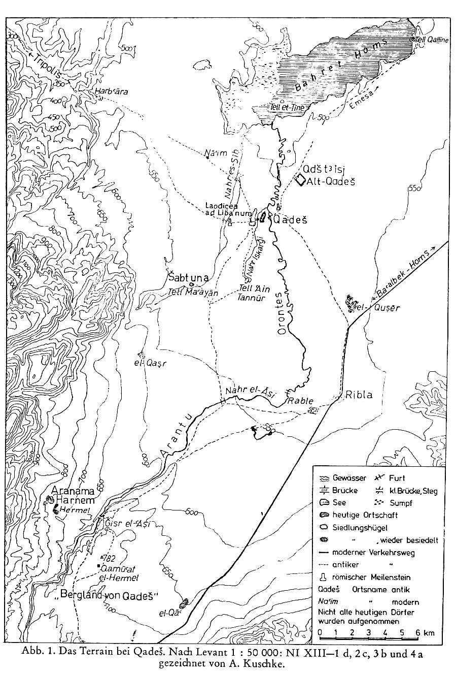
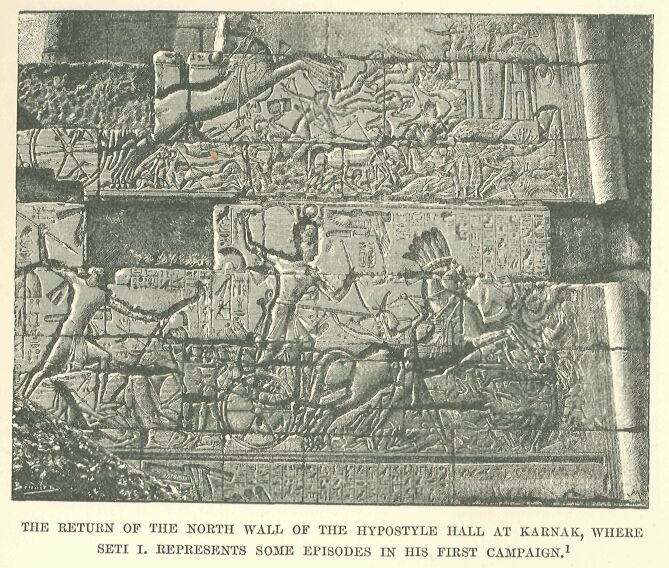
The Hittite, Assyrian and Egyptian Kadesh is identified by scholars as being Tell Nebi Mend, the largest tell within a four mile radius of itself, called “Tell Neby Mendeh” in earlier works, 34°33’26″N, 36°31’10″E, inhabited from the Middle Bronze into the Iron Age, with a destruction by the Sea Peoples. This identification is supported by the fact Ramesses II took 31 days to reach Kadesh from Tjaru (see AJaL, sect. 3), the discovery of two letters to Niqmad (sometimes called Niqmadda, Ari-Teshup), the successor to Aitakama, the King of Kadesh in the Amarna Letters, who was, as the Hittite records attest, murdered by his son, Niqmad, in 1313 BC, the Egyptian reliefs, showing Ramesses coming from the Northwest (the image of Ramesses II from Abu Simbel seems to have been flipped by the artist for reasons of having Ramesses II above, not below the river (Ramesses had to be shown pushing enemy soldiers down, not up, into the Orontes), and the entire relief in the Ramesseum, 2nd Pylon has been flipped by the artist, this seems to be a better representation of the image from the 2nd Pylon of the Ramesseum, the Seti I relief from Karnak, telling of Seti I’s “ascent which Pharaoh, L.P.H, made to take apart the land of Kadesh and the land of Amurru” while differing from Ramesses II’s, still refers to Tell Nebi Mend, Amurru being the mountainous land from Zemar/Sumur to Byblos,), and the fact the river flowing by Kadesh is called the r-n-t (Arantu/Araunti) in most Egyptian texts, and the n-r-t (Anratu/Aunrati) in others, clearly referring to the Orontes River. The fact “Kadesh the Old” (Breasted: “Kadesh the Deceitful”), behind which the Hittites camped, has been found at the MB ruin of Sefinet Nuh, at 34°34’40″N, 36°32’36″E, and the fact a quickly made local stele of Seti I was found at Tell Nebi Mend in 1921 also supports Kadesh as Tell Nebi Mend. The fact that, in the Amarna letters (EA 174-175), Aitakama of Kinsa (Kadesh) assisted the troops of Hatti in setting cities in the kingdoms of Hase/Hasi (Tell Hizzin, 33°57’54″N, 36° 6’14″E) and Hashabu (Tell Hashbe, 33°58’57″N, 36° 4’19″E) on fire shows Kadesh was a reachable distance for troops from the northern Beqa’a. The final nail in the coffin is the fact that the clay from an Amarna letter from Aitakama, king of Kadesh (EA 189) has been shown to be consistent (pg. 97) with the area around Tell Nebi Mend, although, due to contamination, it’s hard to be sure.
The name “Kadesh” was preserved throughout the millennia in the the name of the Lake of Homs, an artificial lake built during the time of Diocletian, called by Abulfeda the “Lake of Qades”, and in a “Quadis” south of the Lake of Homs and NW of Hermel on an 1819 map using pre-1802 information, as shown by the fact that the Lake of Homs was regarded as a long, narrow, strip of water fed by a short branch of the Orontes, which is clearly not the case. This “Quadis” was probably a small mill built of basalt chips, just south of the bridge built over the el-Mukadiyeh, called Tahunet Kades, which was located near 34°33’16″N, 36°30’57″E. Centuries later, Edward Robinson, the great explorer of Palestine and Sinai, expressed puzzlement regarding why the lake should be called “of Qades”-“Why [the Lake of Homs] bears the name of Kedes is unknown. No city or village of that name, ancient or modern, is found in the vicinity.” The first man to propose the identification of Tell Nebi Mend with the Kadesh of Ramesses II was Claude Reignier Conder in the Spring of 1881, who made his identification based almost entirely on false or irrelevant evidence. It was, however, Breasted, who first made a half-competent account of the battle with Kadesh assumed as Tell Nebi Mend. From then on, Tell Nebi Mend was held to be Kadesh by over 80% of Egyptologists. After Pezard’s excavations there (1922), Kadesh was accepted as being at Tell Nebi Mend by all scholars, mostly, due to the exclusion of nearby sites by other excavations.
The identification of Kadesh with Tell Nebi Mend has been rejected by the Velikovskyans. Their argument that Thutmose III could not have went to Naharim without first capturing Kadesh ignores the existence of Damascus. The river south of Kadesh was an artificial moat or ditch, probably re-used from Middle Bronze times, dug from 34°33’5″N, 36°30’56″E to 34°33’N, 36°31’22″E, and mentioned by Thomson in Robinson’s “Later Biblical Researches” as “ma[king] the Tell an island”. The double moat and bridges are unconfirmed, but interesting. The Abu Simbel relief contradicts the text no matter where Kadesh may be located. The fact archeology at Nebi mend is at a primitive stage and has not unearthed walls directly attributable to LB IIB Kadesh should not discourage further excavation of the site. Strabo’s connection of the name “Orontes” with a certain 4th century General Orontes in Geo. 16:2:7 is probably a late tradition, and may reflect the usage of the name only in the lowest parts of the river, near Mount Zaphon, since there is no record of any river “Zaphon”, or “Typhon”, in the Assyrian records. The Orontes was, after all, called Arantu in the Kurkh Monolith of Shalmaneser III and in the records of Ashurnasirpal II. The fantastic statement of the Velikovskyans that the Euphrates had no Egyptian name ignores the fact that it was called by the Egyptians “the inverted water” numerous times. Velikovsky does not even understand what he is saying when he says “In the Egyptian, the initial p could be omitted if it was understood as the definite article”! The “p” in “Prat” is not a definite article! “P”‘s were added as definite articles by the Egyptians, never taken out of the original word. Velikovsky is practically arguing that, since “in the English, the initial the could be omitted if it was understood as the definite article”, the English Ron, Oklahoma, is the Greek Ptolemais Theron, since the Americans omitted the “the” in “Theron”! The “Forest of Baw” of Abu Simbel is not at modern Bab, but, being spelled “Rbw” at the Ramesseum, is at modern Laboue, biblical Lebo-Hamath. (H)Arnam (see Sect. XIX) need not and should not be identified as Shalmaneser III’s Arne, (which is not identified with modern Arme, but with Tell Aran, 36° 7’27″N, 37°20’50″E), but should instead be identified with modern (and ancient, #81) Hermel, whose name is related to (H)Arnam.
Kadesh cannot be Carchemish due to the 31 day travel time limit (if Thutmose III could not even travel 9 mpd, according to the Velikovskyans*, how could Ramesses travel at over 20?) and since Kadesh and Carchemish were listed as separate Hittite allies in the Poem of Pentaur. Also, the description of Kadesh as south of Tunip in the official record of the battle militates against Kadesh being Carchemish. The fact Ramesses II had to cross the Arantu to get to its west side confirms it could not have been the Euphrates. The identification of Tell Nebi Mend with biblical Riblah-in-Hamath, generally identified with the modern village-ford of Rible, 34°27’38″N, 36°32’25″E (not to be confused with Riblah on the east side of Ain/Khirbet ‘Ayyun/A’yoon/Uyun, 32°43’10″N 35°39’60″E) is unfounded, for any fort that was ever built at Riblah, either by Seti I, who never mentioned any Riblah, or by Necho II or the king of Hamath, has long been picked apart by the locals to be used for the building of Graeco-Roman cities, and there is no evidence that Riblah was a fort (2 Kings 23:34 is probably corrupt). While no excavations or pottery surveys have so far been done at Rible, it is known to have been mentioned in an Assyrian letter to Tiglath-Pileser III. Tell Nebi Mend is much better identified as Kadesh for the reasons set out above.
As for the identification of Necho II with Ramesses II, the only proper response is: WTF? Assyrian chronology proves these kings were over 600 years apart. The Abydos (Seti I) and Turin (Ramesses II) king lists are further attestation of this fact. The differences between the two are plain. Their capitals, Avaris/Pi-Ramesse/Qantir and Sais/Sa el Hagar were on opposite sides of the Delta! Tanis/Zoan/Djanet, which Velikovsky considers to be another name for Sais, was, in the Ramesside days, a small provincial town, and only gained importance after the Renaissance (19th year of Ramesses XI), after which Pi Ramesse, ruined due to the shifting Pelusiac, was used as a monument quarry for the Tanite kings. Tanis, however, cannot be Sais. The Saite nome is always identified with the 5th nome, the area of Sa el-Hagar, not with the 19th, or Tanite nome. Djanet (Tanis) and Zau (Sais) were spelled differently by the Egyptians. Sais was put by Strabo, Pliny, and Ptolemy in the Western Delta. Sa el-Hagar has well-charted (not well-excavated) ruins matching the description of Herodotus and some statues of Wahibre/Hophra/Apries. The fact Herodotus considered (2.17) the Saitic branch to be what most call the Tanitic cannot be explained, but the fact some called the Tanitic mouth the Saitic is confirmed by Strabo (Geo. 17:20). Manetho(quoted in Josephus)’s mention that Avaris was located in the Saite nome is not proof of anything but that a copyist can easily misspell “Sethroite nome” (named after Sethrum, otherwise known as Herakleopolis Parva or Hanes (Is 30:4), modern Tell Scherig/Sherig/Belim, 30°58’42″N, 32°10’30″E). Tanis was in the 19th, not the 14th (Avarite/Sethroite) nome.
There are more differences. One ruled for sixteen years, the other for sixty-six years and two months. One had the throne name of Wahemibre, the other, Usermaatre Setepenre. One conquered Gaza in his tenth year, the other kept it as a possession passed on from past generations, one battled Muwatalli II of Hatti, whose brother, Hattusili III, mentioned the battle in several cuneiform tablets, the other Nebuchadnezzar II of Babylon, who mentioned the battle in the Jerusalem Chronicle. Necho built a canal from Bubastis to Suez, Ramesses did not. Finding parallels between Necho and Ramesses is harder than finding parallels between Jesus and pagan deities or Kennedy and Lincoln. Indeed, if Necho II was Ramesses II, how could Taharqa, a very well-attested king in the Assyrian records, make additions to the temples of Ramesses II? Alan Wilson & Baram Blackett’s reading “Nebuchadnezzar” in the gateway to Abu Simbel has not been evaluated by serious scholars, is based on a decipherment of Egyptian hieroglyphics based on the “Khumric” (Welsh) language that the pair made up on their own, and should be discarded. Both Wilson and Blackett are very nutsy Welsh Israelists with no credibility whatsoever. The fact Necho II has few inscriptions in his home country while remaining a mighty king seems to stem from several factors, including that he did not have a Ramesside-length reign, did not have the time or the money to build commemorative inscriptions on temple walls due to his military spending and canal project, and the fact that his capital, Sais, has not been thoroughly excavated. He does have the Serapeum Stele at Memphis recording his burial of an Apis bull and some inscriptions along with Psamtik II’s at the limestone quarries of Mokattam Hills and at Nekhen. Cartouches of his were found at such places as Sidon and Carchemish, not to mention Naucratis and the Wadi Hammamat. This, even though his son, Psamtik II, carried a mighty campaign of destruction of all his monuments and cartouches! I highly recommend New Scientist‘s Oct 19, 1978 review of Ramses II and his time for a further and more conclusive rebuttal.
*Acording to the Velikovskyans, “In order to reach this place, the army which had just crossed the Sinai desert from Egypt would have continued marching for 10 days, covering about 90 miles. Such is the opinion of Breasted and his followers. But according to Danelius, who had kept the 1917 Palestinian campaign well in mind, an army that included cavalry and chariots drawn by horses could not progress that quickly in a country where drinking water is in short supply during the dry season, May to November:
It seems that neither Breasted nor any of his followers has given any thought to this vital question, not to mention other problems of logistics. In this respect, the dispatches sent by General Allenby to the Secretary of State for war during the advance of the Forces in the Philistine Plain are a veritable eye-opener. Gaza had fallen on November 7th 1917. Two days later: “By the 9th, the problem became one of supply … the question of water and forage was a very difficult one. Even where water was found in sufficient quantities, it was usually in wells and not on the surface, and consequently … the process of watering a large quantity of animals was slow and difficult”, wrote Allenby.” (Op. cit., n.84, #’s. 13,14 and after p.113).”68)
And on the very next day, on November 10th:
“The hot wind is an additional trial, particularly to the cavalry already suffering from water-shortage. [This was near Ashdod, in the Philistine Plain]. Owing to the exhaustion of their horses on account of the lack of water … [two mounted brigades] had to be withdrawn into reserve”, on November 11th.”
Applying this situation to Thutmose’s era, Danelius commented:
“There is no reason to suppose that nature was kinder to Thutmose’s troops in May, the month with the greatest number of days with the destructive hot wind blowing from the desert, than to the Allied troops in November. Allenby’s advance, too, was considerably slower than that demanded in Breasted’s calendar for the advance of the Pharaoh’s army: the Allied left wing covered only 40 miles in 15 days along the plain (op. cit., 7, #15), while Breasted suggested 80-90 miles in 10-11 days.”, the Velikovskyans, naturally, forgetting the fact of Ramesses having far more chariots than Thutmose, and Allenby’s force having wheeled guns and a far larger number of infantry, and the fact Gaza and Tjaru in Thutmose III’s record are fixed points, proving Thutmose III traveled 15.6 miles per day (140 miles in 9 days!) on the very badly watered North Sinai coast.
