The first thing one needs for a good study of Jerusalem is a Relief map. For an informative and to-the point early modern account of the history and topography of Jerusalem, relying entirely on the received literature, the present Jerusalem, and the Bible, see “Jerusalem in Bible times“, by Lewis Bayles Payton. Jerusalem is located on several hills of Turonian (Early Upper Cretaceous; 89.3-94 mya) limestone of the Bi’na formation.
Jerusalem had five periods of expansion, its City of David having twenty strata from the EB IB to the Early Ottoman era (see Chronology page):
1. During the MB IIB, after the fall of the Middle Kingdom of Egypt, c. 1720 BC. This began the city’s rise to city-state status, which it lost in the late 16th-15th century and then regained during the 14th, albeit, at a much smaller scale (unwalled, and without capital), and kept until the 10th.
2. After the fall of the Kingdom of Israel, 722 BC. While a temple to YHWH was supposedly founded by Solomon in 947 BC, this cult center did not connect to the City of David until the Iron IIB (c. 780-c. 680 BC), possibly before Hezekiah. Neither were there any post-MB fortifications before the Iron IIB.
3. After the rise of the Hasmoneans in 141 BC. The city again extended back to its Hezekian heights. This expansion continued into the Herodian period, and ended with the destruction of the city in 70 AD.
4. During the Byzantine era, c. 450 BC, when Eudocia was exiled there.
4. During and after the 1840s AD and continuing to this day, largely due to increased access to medical care in the city.
With this in mind, here are Jerusalem Placemarks, north to south (using Nov. 25, 2007 satellite imagery):
1. The Third Wall of Herodian Jerusalem was the most northernly wall in the city’s history. This is the same as the Sukenik-Mayer wall, which was discovered by Edward Robinson in 1838, but, due to him drawing it just a little out of scale, the wall was only re-discovered in the 1927. This identification is considered so because of Josephus’s statement that the city had a circumference of thirty three stadia, his statement that it was opposite the monuments of Helena (certainly the present “Tombs of the Kings”), and that the monuments of Helena were under three stadia from Jerusalem (the current walls are almost exactly four). However, the reference to “caverns of the kings” poses a problem, since those caverns could be the same as Zedekiah’s cave, quite some distance within the wall. It was built by Herod Agrippa, but was left unfinished until repairs were done by Jewish rebels in 70 AD. The gate remains under the Damascus gate are from the wall of Hadrian. Some Herodian towers were also erected around the Damascus gate, but those are not part of Hadrian’s gate.
2. The Garden Tomb area. This includes the following. The Garden Tomb, a probably Iron IIB-C (8th-early 6th century BC) tomb with crusader additions, located at EXACTLY 31°47’2.50″N, 35°13’49″E. Gordon’s Calvary, a rock escarpment and former stone quarry, thought by some (esp. the Wyattists) to be the place of Jesus’s crucifixion, containing a skull-like formation PRECISELY at 31°47′.94″N, 35°13’53.50″E, the top of this escarpment being a Muslim cemetery. The Church of St. Stephen, which was destroyed in 1187 by the Crusaders, and whose tradition mysteriously disappeared in the 15th century, and was rebuilt in 1890 by the French Dominicans as part of the Ecole Biblique.
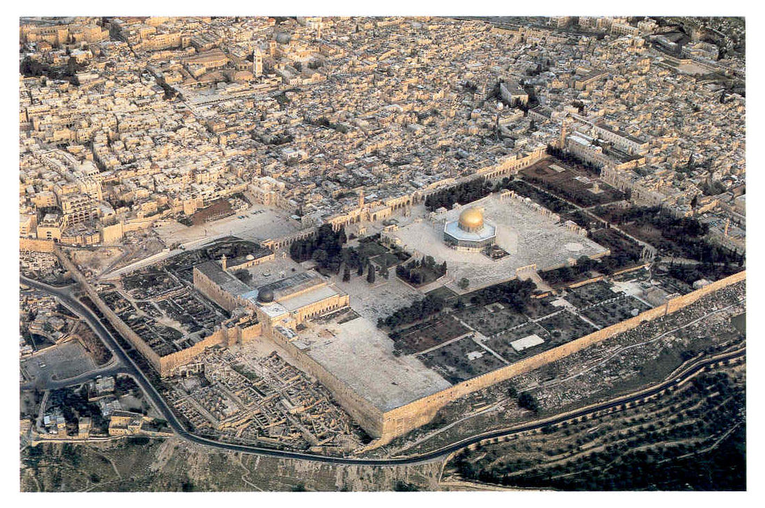
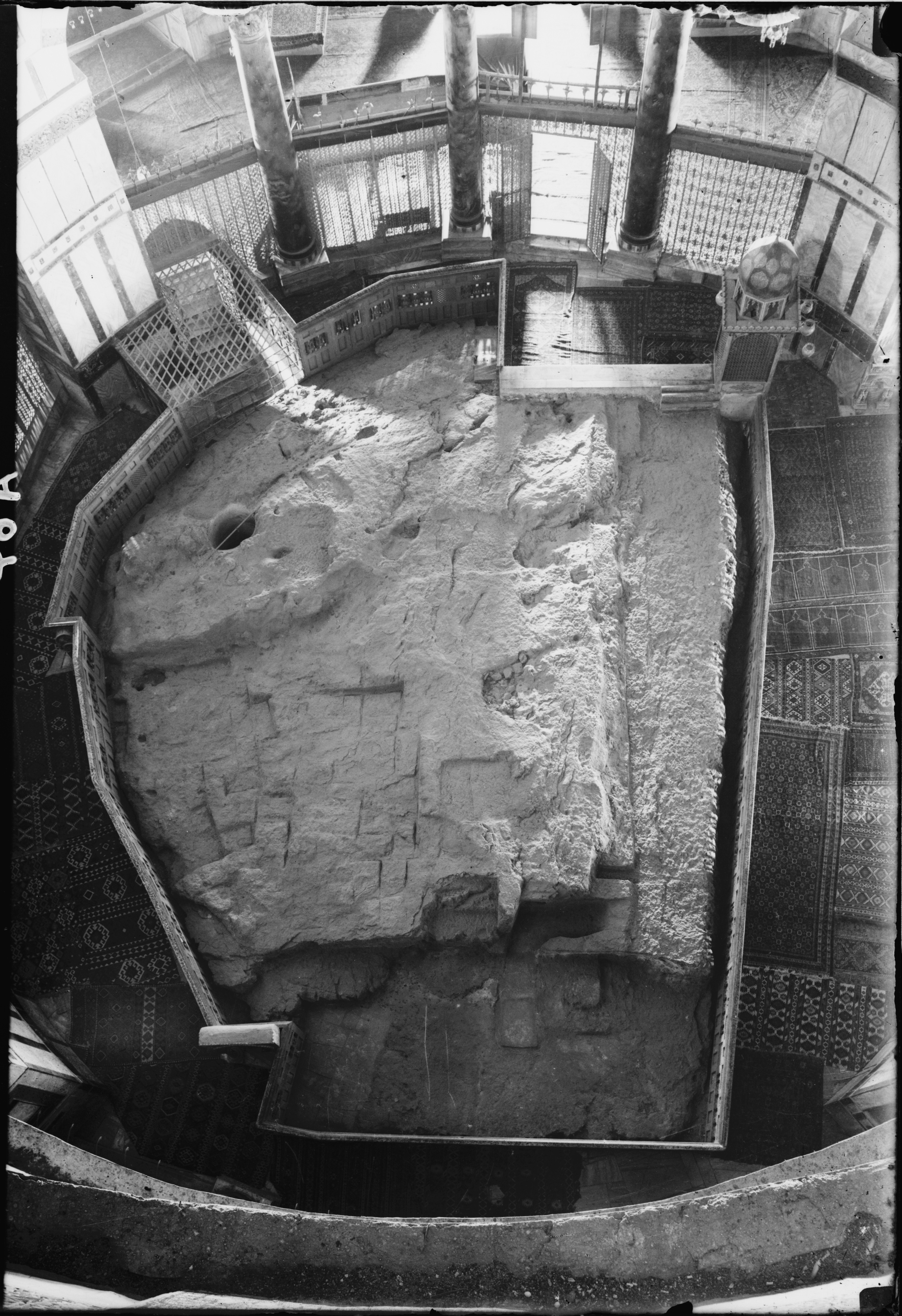
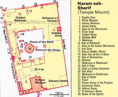
3. The Temple Mount and Fort Antonia (see aerial photograph). The Herodian Temple Mount is the same as the present 37 acre Haram esh-Sharif. The Temple itself was at the top of the mountain, and, consequently, the Holy of Holies (NOT the altar/threshing floor!!!) surrounded the Sakhra in the present Dome of the Rock. The original Temple Mount was built by Hezekiah as a 500×500 cubit structure, which was slightly expanded by the Hasmoneans to the south. It was later expanded by Herod to what it is today. For this matter it is best to listen to Leen Ritmeyer. According to him, the Ark of the Covenant is in a niche in the Sakhra just to the north of the trapezoidal-like niche.
The Gihon Spring option for the Temple is entirely based on gross misunderstandings of certain passages and words of pre-modern literature by Dr. Ernest L. Martin, who, when critiquing Leen Ritmeyer, read his interpretation into texts, failed at basic logic, lied about Leen’s views, shouted, ignored alternative explanations, dismissed the Jebusite fortified reservoir discovered by Reich and Shukron, misunderstood the word “foundations”, overstated his case, name-called, claimed certainty about future matters, and belittled Leen’s experience while bragging about his own. It almost makes me feel safer now that such a man is no longer living. In any case, the Gihon option is not tenable for obvious reasons, most notably for lack of space for the Temple Mount of Josephus and the Mishnah between the the ruins exposed in the City of David and Ophel excavations (this should be visible in any excavation; the City of David under the Monarchy was unwalled until the 8th century BC). The Gihon only had one passageway up to the City of David, and that is the Middle Bronze access tunnel in the Warren’s Shaft System (not connected to Warren’s Shaft itself), from which water did not magically burst upwards, and which, in any case, would become useless when Hezekiah’s tunnel was built. The water used in the temple precincts came almost entirely from cisterns. The Graeco-Roman accounts of a spring being in the temple precincts are probably borrowed from Joel 3:18, most probably indirectly. The Gihon Spring option also has no support from the Bible or from Josephus, who, in his discussion of the hills Akra and the Lower City, clearly excludes the temple from being in either of those areas. 1 Kings 8:1-6 nowhere implies the Ark was returned to the City of David. In Graeco-Roman understanding, “foundations” meant the stones that were below ground (the Israelis lowered the ground level by two courses when building the plaza)and “four-square” meant “four-cornered”, not equilateral. Josephus nowhere implied the foundations themselves were dug up.
Fortress Antonia (a replacement of the Hasmonean Baris, see here for location), a fortress holding a part of a Roman legion (first the XII Fulminata, after 48 AD the 3rd Augusta) had some of its foundations overthrown, but some of its masonry still remains. Even though it was only roughly 28000 square feet (around 80×350), the fortress was still as in Josephus’s description (emphasis mine), excepting in the height of the rock scarp, due to the fact it had four to eight stories and looked like a tower:
“Now as to the tower of Antonia, it was situated at the corner of two cloisters of the court of the temple; of that on the west, and that on the north; it was erected upon a rock of fifty cubits in height, and was on a great precipice; it was the work of king Herod, wherein he demonstrated his natural magnanimity. In the first place, the rock itself was covered over with smooth pieces of stone, from its foundation, both for ornament, and that any one who would either try to get up or to go down it might not be able to hold his feet upon it. Next to this, and before you come to the edifice of the tower itself, there was a wall three cubits high; but within that wall all the space of the tower of Antonia itself was built upon, to the height of forty cubits (58 feet). The inward parts had the largeness and form of a palace, it being parted into all kinds of rooms and other conveniences, such as courts, and places for bathing, and broad spaces for camps; insomuch that, by having all conveniences that cities wanted, it might seem to be composed of several cities, but by its magnificence it seemed a palace. And as the entire structure resembled that of a tower, it contained also four other distinct towers at its four corners; whereof the others were but fifty cubits (78 feet) high; whereas that which lay upon the southeast corner was seventy cubits (102 feet) high, that from thence the whole temple might be viewed; but on the corner where it joined to the two cloisters of the temple, it had passages down to them both, through which the guard (for there always lay in this tower a Roman legion) went several ways among the cloisters, with their arms, on the Jewish festivals, in order to watch the people, that they might not there attempt to make any innovations; for the temple was a fortress that guarded the city, as was the tower of Antonia a guard to the temple; and in that tower were the guards of those three. There was also a peculiar fortress belonging to the upper city, which was Herod’s palace; but for the hill Bezetha, it was divided from the tower Antonia, as we have already told you; and as that hill on which the tower of Antonia stood was the highest of these three (perhaps referring to those of the E. ridge???), so did it adjoin to the new city, and was the only place that hindered the sight of the temple on the north. And this shall suffice at present to have spoken about the city and the walls about it, because I have proposed to myself to make a more accurate description of it elsewhere.”
Indeed, Josephus’s description conflicts with the Gihon Springers’ hypothesis because of the fact the Herodian Temple Mount in no way looks like a tower. Also fatal to the Gihon Springer’s hypothesis is Josephus’s description of Titus viewing the Temple enclosure on Mount Scopus, beyond the Mount of Olives.
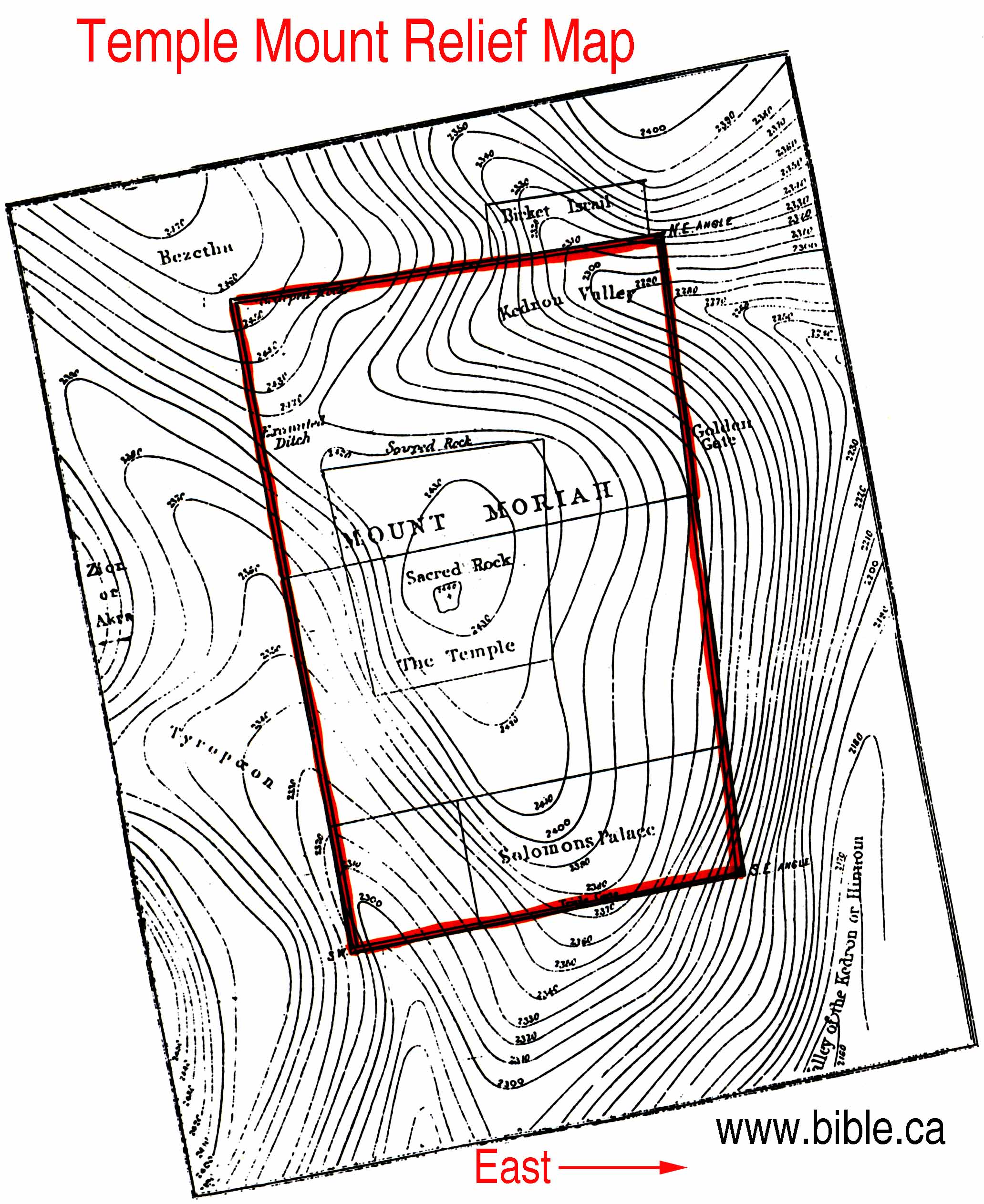
The Temple Mount Sifting Project shows that the Late First Temple settlement extended well into the Temple Mount, as does the Hezekian masonry. For a good map of the present Temple Mount, see here. For elevations, see this map.The Fortress Antonia/Hasmonean Baris and the pre-Herodian (Hasmonean/Hezekian?/Middle Bronze?) defense structures of the Square Temple Mount are not the same thing, and there was a moat N. of Antonia). The gates of the Herodian Temple Mount may be seen here.
4. The Givati Parking Lot Excavation (PRECISELY 31°46’27.67″N, 35°14’6.54″E) is a 3500 square ft. excavation area excavated under the supervision of Doron Ben-Ami. Before him it was excavated by Shukron and Reich in 2005. According to Ben Ami, this area was inhabited throughout Iron II (even IIa), was uninhabited during the Persian period, but was re-inhabited in the Early Hellenistic period. It contains what is probably a palace of Helena of Adiabene.
For excavation areas in the Siloam area, see here. For excavation areas in the city of David, see here. For photograph of the ridge, see here.
5. The Stepped Stone Structure (Area G), of Iron IIa (MCC-980-840 BC, LC-920-840/760 BC) date (see Mazar) is located at EXACTLY 31°46’25.4″N, 35°14’10″E (judging by the red-roofed buildings in the Area G photo). This area was the northernmost expansion of the Persian period “secular” Jerusalem. E. Mazar’s present excavations are in Area H, 31°46’26.21″N, 35°14’9.23″E.
6. The Gihon (31°46’23.60″N, 35°14’12.50″E), also known as the Virgin’s Well, ‘Ain Sitti Maryam (“spring of the Lady Mary”), or, as called by the Arabs, ‘Ain Um el (or ed) Daraj (“spring of the mother of steps”), never mentioned as a spring in the Bible, as the Jordan was never mentioned as a river, was the primary water source of Jerusalem before the Hellenistic period. Hezekiah built a tunnel c. 703-701 BC to divert the Gihon’s water to a place which could be protected from the Assyrians, still functional today. The spring can be reached from the Spring House.
7. The Citadel. This was originally built by Herod and, due to its strength, was not attacked by the Romans in 70 AD. It was identified with David’s Palace by the Byzantines, which is why the Ottoman minaret is called the Tower of David, and the street below it is called David’s. It was rebuilt by the Ottomans into what we see in the present day. Out of the towers Phasael, Hippicus, and Mariamne, all named by Herod, only one, not the Mariamme, remains.
8. The bath house of the Legio X Fretensis (31°46’34.50″N 35°13’56.80″E). This is the only building of this legion’s camp that has been found in Jerusalem besides one near the SW corner of the Temple Mount.
9. The Broad Wall, built by Hezekiah in response to the Assyrians, is one of the most visible stretches of Hezekian fortification on the Western Hill in existence, being 23 feet wide. The Gennath gate, possibly the gate in Letter to the Hebrews 13:12, is just to the west of this wall segment. Download KML file here. View KML file here.
10. En Rogel, or Bir ‘Ayyub (31°46’3.37″N, 35°14’8.70″E), translated “Job’s Well”. The name “En-Rogel” means “Spring of the Foot-Treader”, and should possibly be translated “spring of the fuller (or launderer)”. The name “Job’s Well” is probably a corruption of “Joab’s Well“.
The Pools of Jerusalem:
1. The Birket Mamilla ( 31°46’41″N, 35°13’15″E)-Identified in the 19th century as the Upper Gihon, this pool was on the aqueduct line from Etam.
2. The Birket es-Sultan-Identified in the 19th century as the Lower Gihon. Possibly the Roman era Serpents Pool. Located to the SW of the Armenian quater.
3. The Towers Pool, or Pool Amygdalon (Greek “Almond”, corruption of Heb. “migdalim”, towers) is located some 60 yards to the SW of the Church of the Holy Sepulchre and just to the N. of David St. This pool is today called by the Arabs the Birket Hammam et-Batrak (Pool of the Patriarch’s Bath) for the Crusader Patriarch had his bathwater come from this pool. It used to be called the Pool of the Holy Sepulchre before it became identified with the Pool of Hezekiah during the 19th century, the early explorers not realizing the tradition identifying Gihon with Siloam was, in fact, correct to an extent.
4. The southeastern (Siloam area) pools, which are covered in this post.
The Valleys of Jerusalem
1. el-Wad, or the Tyropoeon, translated as “The Valley of the Cheesemongers”. This valley is described by Josephus and runs through the middle of Jerusalem, from the Damascus Gate to the Pool of Siloam.
2. Wadi Sitti Maryam, or the Kidron, is the valley to the east of Jerusalem, between it and the Mount of Olives.
3. The Wadi er-Rababi, the valley to the west and south of Jerusalem, is the Valley of the Son of Hinnom. Child sacrifices were said to have been done here, probably below the cisterns in that valley.
(NOTE: This page will be continuously updated, even though it hadn’t been updated at all between February 2012 and June 2013)

Christ Crucifixion site and the Ark of the Covenant found burred under a trash pile in Jerusalem.
http://arkofthecovenant2.blogspot.com/
See my “Saga of the Ark of the Covenant” for a rebuttal.
Dear Sir, thank you for touching on the Martin/Ritmeyer Feud. I know of Leen Ritmeyers credentials and resume very well and enjoy his books. One annoying item I hoped you could answer me. Martins quote of Josephus that when all was done, nothing but the Antonia Fortress could been seen standing. Meaning the Kotel, the Western Wall sswhich still stands can only mean that Martins theory that it was a part of the Antonia Fortress is correct as all theTemple Walls and building lay waste and broken on the ground.
Also my studies have led me to understand that many thing Shimon Hashmonean was the Wicked Priest of the dead sea scrolls for doing exactly what Martin claims, razing the oriignal Mount Zion and moving it north to the place now know as the Temple Mount, or Haram al Sharif to the Muslims
I hope my questions are not too foolish
Sincerely Yours
Avi
As says Jeffrey J. Harrison,
“The inherent contradiction of Martin’s claims emerges most dramatically in another set of passages that he seeks to minimize, since they directly challenge his idea that the Temple Mount was the Antonia Fortress (pp. 35-37). Martin himself claims that only the Antonia Fortress remained after the war of the whole ancient city of Jerusalem, “splendidly in place in the lower courses” (p. 173). But Josephus says, by contrast, that “Titus gave orders to his soldiers that were with him to dig up the foundations of the tower of Antonia” (Wars 6.2.1 [6.93]). This order was quickly carried out: “The Roman army had, in seven days’ time, overthrown the foundations of the tower of Antonia” (Wars 6.2.7 [6.149]; see also 6.5.4 [6.311]). If “digging up the foundations,” when used of the Temple and the city, refers to removing the foundations, as Martin claims, then this means that the Antonia, too, was completely destroyed and removed, just like the rest of the city. And as a result, his entire theory of identifying the Temple Mount with the Antonia Fortress falls to the ground. Since the same language is used by the same writer both for the destruction of the Antonia and for the destruction of the Temple and the city, there is no reason to believe Martin’s claim that one was completely destroyed and removed while the other was left essentially intact.”
In any case, from where would the temple be moved by Simon? Indeed, due to the lack of evidence for a fortified capital until the mid-8th C BC from the City of David excavations, I suggest it was only the Square Haram esh-Sharif which was fortified until c. 748 BC (just after the death of Jeroboam II). This is supported by 2 Kings 14:13.
How can you explain that biblical text tell us that the City of David was located on the southwestern hill of Zion? Did biblical authors ever see Iron Age Jerusalem?
2 Chronicles 32:30 and 2 Chronicles 33:14 clearly place the City of David on the SE hill, not the SW hill. As Chronicles is a Late Hellenistic work, it makes sense to place the Iron Age City of David on the SE hill as well. Josephus does place the stronghold of Zion on the SW hill, if I remember correctly, but, by his time, the SW hill had long been fortified by the Hasmoneans.
Then, when have been written 2 Sam. 5:7, 1 Kgs. 3:15 (LXX), 1 Kgs. 8:1?
I support the Southern Conjecture view. The Temple was absolutely NOT on a Mountain Top.
I considered the Gihon Spring view once but rejected it.